![[ Shows Colona ] Map of the United States and Mexico. Published . . . Under the Direction of Col. Carlos Butterfield. December 1859 By Alvin Jewett Johnson & Ross C. Browning](https://storage.googleapis.com/raremaps/img/small/103272.jpg)


|
||

|

|
|

|
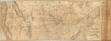
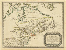
Decorative large format separately issued maps of the United States, naming Colona (Colorado Territory).
Carlos Butterfield was an early advocate of the creation of regular a regular steamship and mail service between the United States (either New Orleans or Mobile) and the various major Mexican ports in the Gulf of Mexico. Butterfield published a promotional tract for his project, which was widely disseminated immediately prior to the Civil War. While copies of the promotional tract are not uncommon, only a few copies were bound with this exceptional map of the United States, showing among other things one of the earliest appearances of the Territory of Colona on a map, and one of the very few published in the United States.
The map was published by Johnson & Browning, who had only recently separated from JH Colton & Company in 1859 to commence their own publishing venture in New York and later Richmond, Virginia, the map is rich with details, most notably, the overland route from Franklin, Missouri to El Paso, Texas and then on to Los Angeles. The map is also one of the first appearances of the name Denver City on a map. The Denver City Town Company was founded by William H. Larimer from Leavenworth, Kansas Territory. It is quite possible that this map represents the earliest appearance of the name Denver City on a map, pre-dating the appearance of the name on JH Colton's 1860 edition of the Territories of New Mexico and Utah map, which is one of the earliest known appearances. Not in Wheat or Howes. The map has been flattened and archivally backed, with minor restorations to a few folds, but is in generally nice condition.
Alvin Jewett Johnson (1827 - 1884) was an American map publisher. Born in Wallingford, Vermont, he received only a basic public education, but he still served as a school teacher for several years before moving to Richmond, Virginia and, in 1857, New York City. Johnson also worked as a book canvasser for the map publisher J.H. Colton.
Johnson's name first appears on maps published with Samuel N. Gaston and D. Griffing Johnson (no clear relation) in the mid-1850s, and his name (along with Ross Browning) appeared on Colton's atlas maps of 1859 and 1860. Although map historian Water Ristow speculates that Colton sold his copyrights to Johnson and his business partner, fellow Vermonter Browning, a more likely theory is that Johnson and Browning financially bailed out the Colton firm in exchange for the right to use Colton’s existing copyrighted map plates. The first Johnson maps were mostly reissues of earlier Colton maps. Indeed, Johnson's earliest works described his firm as the “Successors to J. H. Colton and Company”. Johnson converted the original Colton steel plate engravings to lithographic stones, allowing his firm to produce more maps at a lower price point.
In 1860, the Johnson firm published its first significant work, the Johnson’s New Illustrated (Steel Plate) Family Atlas. The first edition of the Atlas bears imprints in both New York and Richmond, VA. In 1861, however, following the outbreak of the American Civil War, the Johnson & Browning firm abandoned their Richmond location. Browning seems to have remained in Virginia to pursue other ventures and, in 1861, Browning’s portion of the firm was purchased by Benjamin P. Ward. The 1863 issue of the Atlas was one of the most unusual, it being a compilation of older Johnson and Browning maps, updated 1862 Johnson and Ward maps, and newer 1863 maps with a revised border design.
The 1864 issue of the Atlas is the first true Johnson and Ward atlas. Johnson published one more edition in partnership with Ward in 1865, after which Johnson becomes the sole publisher. The next issue of the Atlas, 1866, is the first purely Johnson atlas with all new map plates, updated imprints, and copyrights. Johnson maps include a unique border style, which changed over the years, but was not copied by other makers. These include a “strapwork border” from 1860 to 1863, a “fretwork border” from 1863 to 1869 and a “spirograph border” in 1870.
In addition to the Family Atlas, Johnson issued numerous wall maps, pocket maps, and, in the 1880s, the Cyclopedia. Johnson frequently updated his western atlas maps and on occasion, more than one update appeared in a single year. Johnson continued to publish the Family Atlas until 1887. In 1879, Johnson brought his son into the business, and their publications have the imprint “A.J. Johnson and Son” and, later, “A.J. Johnson and Co.” Johnson’s son continued the business until it shuttered in 1887.
![[United States Independence After The Revolution] A New Map of North America, with the West India Islands, Divided according to the Preliminary Articles of Peace, Signed at Versailles, 20 Jan. 1783, wherein are particularly Distinguished The United States, and the Several Provinces, Governments &ca, which Compose the British Dominions . . . 1783](https://storage.googleapis.com/raremaps/img/small/70734.jpg)