This item has been sold, but you can enter your email address to be notified if another example becomes available.


|
||

|

|
|

|
Stock# 11595
Description
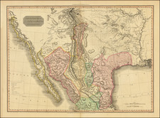
Highly detailed showing the region from the Rocky Mountains, from the Missouri River to the Red River, Plate River and Arkansas River, from the first French edition of Pike's classic account of the first U.S. government expedition to the Southwest.
Of all the editions of Pike, the maps in this French edition are the most beautifully engraved and on the best quality paper. The detail between the Missouri River and the Red River is truly extraordinary, and includes many original notes and observations which make it a source map for all maps which came after. Also includes highly detailed Indian Village and topographical information.
A fundamental map for Western American collections.
![[Austins Colony] Mexico & Guatemala](https://storage.googleapis.com/raremaps/img/small/94054.jpg)
![(Texas - Spanish Colonial Era) [Manuscript document of 1692 concerning Bahia del Espiritu Santo on the Texas Gulf Coast, signed by the Viceroy's secretary, Juan Francisco de Vargas Manuel de Lodeña]](https://storage.googleapis.com/raremaps/img/small/95766.jpg)