|
||

|

|
|

|
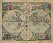
Unique example of Cavazza's extremely rare and highly distinctive map of the world, which originally appeared in Battista Riccoli's Geographicae Crucis Fabrica Et Usus Ad. Rep Mira Facilitate . . . an extremely rare early treatise on chart construction. For reasons which must be left to speculation, this example consists of two examples of the map, which have been joined in the Pacific Ocean to form one continuous map of the world, nearly double the size of the normal map, with all information on the map shown twice, making the center of the map the Pacific Ocean, rather than the Atlantic. The ornate brachia which adorn either side of Cavazza's map were intended to be cut out and used to form an instrument for determining times of daylight or darkness on the earth's surface. Cavazza's map is an exceptionally intricate latticework of geographical detail and decorative vignettes depicting ships and sea monsters. The map is highly detailed and includes over 100 place names in North America, a narrow El Steto d'Anian, Magellanica Sive Terra Australis Incognita (which includes Marco Polo's Beach, several mythical islands in the Atlantic and a host of other interesting early details. Although the map is based on the geography contained in C.J Visscher's map of 1639, Cavazza has added a number of scientific diagrams as well as his own unique style of border decoration. The present example is in flawless original condition, having apparently been joined prior to its original binding into the atlas. Cavazza's map is rare, with only a few examples appearing in dealer catalogues over the past 25 years, the last in 1997 (Old Print Shop, Vol. LVI, No. 7). We are unaware of any other examples of two copies of this or any other map being joined in this manner. A fine dark impression on thick paper, flawlessly joined. Shirley 357.
![[Spectacular Set of Wall Maps of the Continents Dedicated to King Charles II of England, &c.]](https://storage.googleapis.com/raremaps/img/small/93614.jpg)
![(Early Photographic Facsimile of the Mappamundi of Tunuslu Hajji Ahmed) Kemãl ile Naks Olinmis Cümle-I Cihãn Nemunesi [Fully Illustrated Exposition of the World in Its Entirety]](https://storage.googleapis.com/raremaps/img/small/66562.jpg)