|
||

|

|
|

|
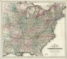
Scarce early map of the United States, showing 17 organized states. Georgia still extends to the Mississippi River, shortly before the organization of Mississippi Territory. In the Old Northwest, the Wabash, Illlinois, Ohio & New Jersey Company lands are shown, as are the Army Lands in northern Tennassee Government. Chicago does not yet appear, but Pt. Fort is shown. Detroit is shown. Maine is not yet a state. Many Indian Tribes are noted. A terrific pre-Louisiana Territory Purchase map.
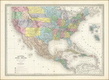
Ambroise Tardieu was an important French cartographer and engraver.
He produced a number of excellent large format maps, including a revised edition of Aaron Arrowsmith's 4-sheet map of the United States. T
Tardieu came from a family boasting a number of fine engravers, and was trained from an early age by his uncle, Pierre Alexandre Tardieu (1756–1844), a leading French engraver. Showing considerable talent in this field, Ambroise persevered and became a celebrated engraver of portraits. In addition he was appointed as geographical engraver for the French government, for which he received a small stipend. In order to eke out this meagre wage, he began to trade in prints, books and maps. He is remembered for more than 800 portraits engraved through his career, many depicting scientists of the period.
Tardieu published a number of atlases, one of which appeared in 1842 and was titled Atlas universel de geographie, ancienne et moderne/dresse par Ambroise Tardieu pour l'intelligence de la Geographie universelle par Malte-Brun.