|
||

|

|
|

|
Rare edition of Mitchell's seminal map of Texas and the West, bound into original brown 16mo leather covers with text entitled "Geographical Description of The State of Texas . . . " published by Thomas Cowperthwait & Company in 1846, which consists of 62 pages and several woodcut illustrations.
The region covered by the map was of particular interest in 1846 because of two recent and related events. In 1845, Texas was admitted into the Union, which prompted Mexico to invade Texas in 1846, thus precipitating the U.S.-Mexican war. General curiosity about the new State of Texas and interest in the war with Mexico led to Mitchell's timely map becoming quite popular. As stated in the "Accompaniment to Mitchell's New Map of Texas, Oregon and California...," the most common source of this map, Mitchell used the latest and best sources for the map, including Arrowsmith's 1841 map of Texas, Fremont's and Emory's maps of their explorations in the region, data from the Lewis & Clark expedition, Nicollet's map of the region between the Mississippi and the Missouri, Wilkes map of Oregon.
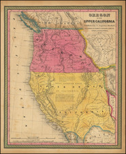
The map shows Texas claims to the Upper Rio Grande in present day New Mexico. These claims were eventually given up as part of the Great Compromise of 1850, in exchange for the U.S. Federal Government's assumption of Texas' public debt. This example is bound into "Geographical Description of The State of Texas; Also, of that Part of The West Coast of North America, Which Includes Oregon, and Upper California, With Maps." The map's appearance with the "Geographical Description" is unrecorded, as normally, two small maps on a single sheet were appeared in this very rare guide. As noted by Rumsey, the "Geographical Description" is a rare guide and map (actually two maps on one sheet) that is a "cousin" of Mitchell's "Accompaniment to Mitchell's New Map of Texas, Oregon and California with The Regions Adjoining" also issued in 1846.
The two full color maps which normally appeared in the work are titled "Map of That Part of the West Coast of North America Comprising Oregon and Upper California" (10 x 8 inches) and "Map of the State of Texas With Portions of the Adjoining Regions" (10 x 8 inches) both printed on one sheet. These maps are earlier states of similar maps with slightly different titles that appear in Mitchell's School Atlas of 1846, maps #13 and #15, published by Thomas, Cowperthwait & Co. The maps in the school atlas were copyrighted by Mitchell. Rumsey presumed that Thomas, Cowperthwait issued the Geographical Description to compete with Mitchell's guide, yet somehow had Mitchell's cooperation in using the maps and the covers. Rumsey notes that the Geographical Description is much rarer that Mitchell's guide and sold for two and one half times more at the Streeter sale.
Our copy of the Geographical Description is the only known example to include Mitchell's larger map of Texas, Oregon & Upper California, rather than the normal 2 maps on a single sheet. For details on the Geographical Description, see Streeter 3325; Howes M688 (not in Cowan, Graff, Eberstadt, Decker, Sabin, Wheat, Wagner Camp). As with the Streeter copy, the tables apparently referenced by Smith (3497) are not present, apparently making this the first edition according to Streeter. Minor toning to the map and minor repaired tear where the map has been rejoined to the text. An apparently unique variant of one of the most influential maps in Western American History.
For over fifty years, Samuel Augustus Mitchell, his son, and his successors some of the most prominent publishers of maps and atlases in the United States. Samuel Augustus Mitchell Sr. was born in Bristol, Connecticut on March 20, 1792. His father had emigrated from Scotland in 1773. While little is known about his early schooling, it is known that Mitchell found the quality of early geography text books to be lacking, and determined that he would write and publish better works. This decision led him to relocate to Philadelphia in 1829 or 1830, which was then the center of commercial publishing in America.
Mitchell’s first cartographic work was the re-issue of Anthony Finley’s New American Atlas in 1831, a work first issued by Finley in 1826, in response to Henry Schenk Tanner’s monumental work of the same title, issued in serial format from 1818 to 1822 and as a complete work from 1823 onward. While the map content in Mitchell’s edition of the New American Atlas is the same as Finley’s edition, each map has been significantly improved and revised, primarily with the addition of new towns and roads. This is especially true in the south and west. Finley had originally collaborated with D.H. Vance and J.H. Young in the preparation of the maps, although Vance’s name is removed from the Mitchell edition. Mitchell continued to work with Young, an association which would continue for several decades.
Following publication of the New American Atlas, Mitchell began issuing the individual maps in pocket map format. From 1834, Mitchell began offering reduced sized Tourist Pocket Maps of a number of states in the United States. J.H. Young and D. Haines are listed as the engravers on these maps. In 1832, Mitchell offered the first edition of his Travellers Guide Through the United States, A Map of the Roads, Distances, Steam Boat & Canal Routes &c. By J.H. Young . . ., which would become one of his most popular and enduring works. The map of the United States was done by steel engraving, one of the earliest uses of the technique in map publishing in America. In the same year, the first edition of Mitchell’s Map of the United States, by J.H. Young was issued, bearing the copyright date of October 10, 1831. This map would be revised and issued until 1844. Young also compiled A New Map of the United States in 1833. These two wall maps would come to dominate the market and their success led to several later US wall maps issued by Mitchell. This second map was also issued under the title of Mitchell’s Reference and Distance Map of the United States, which was printed until 1851.
Mitchell was neither a cartographer nor an engraver. His primary function was as the editor and business manager of his publishing company, with Young working as the primary maker of maps. Beginning in 1839, Mitchell also began publication of his school atlas. This work and variant editions for older and younger students, was issued by Mitchell and his successors from 1839 to 1886. In 1845, Mitchell acquired the rights to Henry Schenk Tanner’s New Universal Atlas from Carey & Hart, which had previously acquired the copyright from Tanner and had published editions of 1843 and 1844. Mitchell changed many of the maps and issued two editions of the atlas in 1846. He changed the copperplates to lithography, utilizing Peter S. Duval in Philadelphia to produce the stones. Mitchell re-issued the atlas at least annually until 1850, when he sold the rights to the work to Thomas, Cowperthwait & Company.
In 1860, Mitchell’s son, Samuel Augustus Mitchell Jr. began issuing Mitchell’s New General Atlas. While his father had continued to issue wall maps and other works, this appears to be his son’s first entry into the trade. The New General Atlas was issued by SA Mitchell Jr. until 1887. From 1880 to 1887, Bradley & Company also published the atlas. Various other minor publishers, including A.R. Keller, produced editions as late as 1894. The elder Mitchell died in 1868. Samuel Jr. continued the business until the 1890s. At its height, the Mitchell Company employed 250 people and sold 400,000 publications annually.
![[Drake's Bay to Fort Bragg] Bodega Head to Abalone Point From The Latest United States Government Charts . . .](https://storage.googleapis.com/raremaps/img/small/73078.jpg)
![[Berkeley] This Is The Map of Berkeley Town Its Streets Go Winding Up & Down An Oak-Covered Campus It Wears For A Crown With People & Places of Renown](https://storage.googleapis.com/raremaps/img/small/97201.jpg)