|
||

|

|
|

|
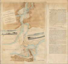
An excellent example of the third state of Seutter's map. The map is based upon Jansson's map of 1651. Seutter replaces the Restitutio view of New York City with a new view of New York entitled Neu Jorck sive Neu Amsterdam, with a key to the view in Latin. Above the view is an elaborate scene depicting natives and gods presenting tribute to the English monarch George II. The course of the Delaware and Hudson are separated, unlike early editions of the map. This is the first map in the series to show the boundaries of Massachusetts, New England, New York, New Jersey, and Pennsylvania with a printed lines, as earlier examples had previously left the delineation of the boundaries to the colorist. Philadelphia is now shown as a set of houses in relief, rather than a ground plan. This is the third state of the map, distinguishable by the 2 lines of text below the words August. Vind in the title cartouche. The map is richly embellished with many animals and other decorations. Without doubt, one of the most decorative maps of the region produced during the 18th Century. Tiny reinforced centerfold split, just entering printed image, else an excellent example in fine old color. Increasingly scarce on the market. The genesis of this map was studied in great detail by Tony Campbell in an article entitled The Jansson-Visscher Maps of New England, which appears as Ch. 8 of Tooley's Mapping of America.
Matthäus Seutter (1678-1757) was a prominent German mapmaker in the mid-eighteenth century. Initially apprenticed to a brewer, he trained as an engraver under Johann Baptist Homann in Nuremburg before setting up shop in his native Augsburg. In 1727 he was granted the title Imperial Geographer. His most famous work is Atlas Novus Sive Tabulae Geographicae, published in two volumes ca. 1730, although the majority of his maps are based on earlier work by other cartographers like the Homanns, Delisles, and de Fer.
Alternative spellings: Matthias Seutter, Mathaus Seutter, Matthaeus Seutter, Mattheus Seutter
![[Cape Cod area / Nantucket / Martha's Vineyard / Boston Bay]. (Revolutionary War Era Manuscript Sea Chart)](https://storage.googleapis.com/raremaps/img/small/69611.jpg)
![(Three Days at Gettysburg) Map of the Battlefield of Gettysburg July 1st, 2nd, 3rd 1863. . . [Three Maps]](https://storage.googleapis.com/raremaps/img/small/101769.jpg)