|
||

|

|
|

|
A RARE Map
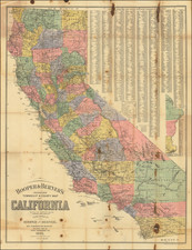
This Roadless Area Review and Evaluation (RARE II) map of California was published by the United States Department of Agriculture Forest Service in June 1978. It details roadless and undeveloped areas in California at a scale of 1:1,000,000. The legend identifies existing wilderness, administratively endorsed wilderness proposals, RARE II roadless areas, other national forest system lands, congressionally designated study areas, and residual primitive areas not previously endorsed. A comprehensive table lists area codes, names, and the gross and net acres for regions such as Klamath, Mendocino, Sierra, Sequoia, and Tahoe. Information is provided by the California Region office in San Francisco, CA, and the Intermountain Region office in Ogden, Utah.
Background
The "Roadless Area Review and Evaluation (RARE II)" was an initiative by the U.S. Forest Service to evaluate and determine the best use of roadless areas within the National Forest System. The aim was to expedite decisions on which areas should be designated as wilderness and which should be allocated for nonwilderness uses to support communities and industries. This process involved public input and comprehensive inventory and evaluation phases.
RARE II Process
RARE II involved creating an inventory of potential wilderness areas, evaluating gaps in the National Wilderness Preservation System, and analyzing social and economic impacts of wilderness designation. The process included public review and comment on a draft environmental statement, followed by a final statement listing areas recommended for wilderness designation and those for nonwilderness uses, with recommendations forwarded to Congress.

![Wines from California | Wine Land of America [Vineyard scene]](https://storage.googleapis.com/raremaps/img/small/93655.jpg)