|
||

|

|
|

|
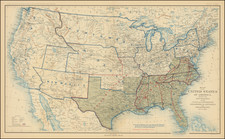
Wall Map of the British & French Colonies In North America, Reduced From Henry Popple's Monumental 20 Sheet Map
Spectacular full original color example of the 4-sheet Covens & Mortier's edition of Henry Popple's seminal map of North America.
Henry Popple worked with the Board of Trade and Plantations in 1727, during a period when boundary disputes among both the colonists and the French began to accelerate the need for detailed maps. In 1730, the Board began requesting detailed maps of the entirety of the provinces and contiguous regions. Popple issued an announcement for his map in 1731 but did not complete work on his 20-sheet map until 1733. Despite his connection to the Board of Trade and Plantations, Popple's map was not a commercial success and did not sell well until the publication of the map was taken over by William Henry Toms and Samuel Harding in 1739. With the outbreak of the War of Jenkin's Ear, public interest in the map spiked, and so did its commercial success. In 1746, the rights to Popple's map were sold to Willdey and Austen, who published the map until Austen died in 1750.
As noted by Barbara McCorkle in America Emergent:
Little is known of Henry Popple except that he came from a family whose members had served the Board of Trade and Plantations for three generations, a connection that must have been a factor in his undertaking the map, his only known cartographic work" (McCorkle 21.)
Popple's map is the first large-scale printed map to show the thirteen colonies. The map is nearly 8 feet square when joined. The map shows the extent of the British, French, and Spanish colonial possessions. The information on the map was based on Popple's work at the Board of Trade and Plantations in London. Popple's map was widely copied by other cartographers and remained the standard map of North America for several decades. The map was issued both as a wall map and as an atlas.
Popple produced this map under the auspices of the Lord Commissioners of Trade and Plantations to help settle disputes arising from the rival expansion of English, Spanish and French colonies. At the time of its publication, "France claimed not only Canada, but also territories drained by the Mississippi and its tributaries - in practical terms, an area of half a continent" (Goss, The Mapping Of North America page 122.).
Popple's map was also the first English map to name all the original thirteen colonies and one of the first maps to show Georgia. The new Colony of Georgia was chartered in London in July 1732, but developed only in early 1733, with the landing of James Edward Oglethorpe and his small party of 120 colonials. Oglethorpe returned to England in 1734 and met with the King on July 20, 1734, showing him "several charts and Curious Drawings relating to the new Settlement of Georgia". The same charts and maps must have been almost immediately made available to Popple by Oglethorpe, as Popple immediately incorporated this new information into a corrective paste-down mounted on Sheet 10 in State 3 of the map. The new information regarding Georgia was then engraved onto the map in State 4 published in late 1734 [Babinski, note 12, 13]. The new Colony of Georgia was considered by the British as an attempt to create an important protective buffer between the more densely populated English Colonies in the north and the Spanish in Florida.
Popple's map was both a cartographic landmark and a visual icon among the social elite of the British Colonies. As noted by Bruckner in The Geographic Revolution in Early America. . .
British Americans frequently imported imperial maps during the eighteenth century. Decorative wall maps showing British possessions in North America were favorite articles, purchased primarily by the colonial elite. Strategically displayed in formal settings of the home or provincial office, these maps painted bombastic scenes of territorial conquest and signified the range of the British Empire. For example, maps like Henry Popple's Map of the British Empire in America (1733) reached American audiences upon special orders by the Board of Trade and Plantations, and colonial politicians like Benjamin Franklin eagerly requested Popple's map for public display.
The Covens & Mortier edition is known in two states:
- State 1: 1737 (title references ... French Spanish and Hollandish Settlements).
- State 2: 1742 circa (title references ... French Spanish and Dutch Settlements)
Covens & Mortier was one of the largest and most successful publishing firms in Dutch history and continued in business for over a century. Pierre Mortier the Elder (1661-1711) had obtained a privilege in 1690 to distribute the works of French geographers in the Netherlands. After his widow continued the business for several years, Cornelis (1699-1783) took over in 1719.
In 1721, Mortier forged a partnership with Johannes Covens (1697-1774), who had recently married Cornelis’ sister. They published under the joint name of Covens & Mortier. In 1774, upon the death of his father, Johannes Covens II (1722-1794) took over his father’s share. In 1778, the company changed its name to J. Covens & Zoon, or J. Covens & Son.
Covens II’s son, Cornelis (1764-1825), later inherited the business and brought Petrus Mortier IV back into the fold. Petrus was the great-grandson of Petrus Mortier I. From 1794, the business was called Mortier, Covens & Zoon, or Mortier, Covens, & Son.
The business specialized in publishing French geographers including Deslisle, Jaillot, Janssonius, and Sanson. They also published atlases, for example a 1725 reissue of Frederik de Wit’s Atlas Major and an atlas, with additions, from the works of Guillaume Delisle. There were also Covens & Mortier pocket atlases and town atlases. The company profited from acquiring plates from other geographers as well. For example, the purchased Pieter van der Aa’s plates in 1730. Finally, they also compiled a few maps in house. At their height, they had the largest collection of geographic prints ever assembled in Amsterdam.