


|
||

|

|
|

|
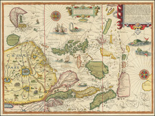
Linschoten spent much of his early life traveling through the Indies. In 1596, he published his Itinerario, which became a standard navigational guide in the years after its publication and is among the most important sources for 16th Century Southeast Asia, providing one of the first detailed works on the region. This map relies heavily upon Spanish & Portugese sources, to which Linschoten had access. The maps draws on the work of Fernao Vaz Dourado for much of Southeast Asia and Japan. China is based upon the work of Barbuda. The Philippines is drawn from de Lasso, most notably the curious orientation of Palawan. In other regions, Linschoten draws upon the reports of Marco Polo, most notably for the location of the mythical land of Beach provincia aurifera, south of Java Mayor. Linschoten follows Plancius in confusing Seram with New Guinea, a reference which was noted by Thomas Forrest, who explored New Guinea for the English and cited the map as proof that the islands of New Britain discovered by Dampier were the same archipelago as the Solomon Islands. In Borneo, Linschoten follows Plancius in identifying the region visited by Don Manuel of Lima in 1537, a reference apparently derived from Lopo Homem, Bartolomeu Lasso and Vaz Dourado. On the mainland, the course of the Mekong is west of the treatment of Ramusio, significantly distorting the region. Ayuthaya appears twice, once as Odia, and, just over the other side of the river, it appears again as Siam. Linschoten rejected the inland sea shown by Lasso in northern Malaya, and adds a reference to Singapore. Chiang Mai is adjacent to Ayuthaya, on the Mekong. Lake Chiang Mai, the supposed source of the major rivers of Southeast Asia, has moved significantly to the west. Linschoten includes four large lakes in the Chinese interior, based on a similar treatment by Barbuda and Chinese legend. Corea is shown as an island. The map is richly embellished with two compass roses, sea monsters and sailing vessels, along with a number of animals in the interior of China. A nice wide margined example with attractive wash color. One expertly repaired tear near the centerfold and one thin spot, but generally a very nice example on thick strong paper, with wide margins. Without question, one of the most decorative and influential regional maps of the 16th Century. Cortazzi 22; Schilder #18; Walter #12; Suarez fig. 91; Quirino 27 and 77.
![[Japan] Imperium Japonicum in sexaginta et octo Provincias divisum. Ex ipsorum Japonensium mappis & Observationibus Kaempferianis, qua fieri licuit fide & cura descripotuim a Joh: Casparo Scheuchzer . . .](https://storage.googleapis.com/raremaps/img/small/85601.jpg)
![[Summer Palace] The Map of Yu Ho Yuan Won Shou Shan Including Kuen Ming Hou Near of Peking](https://storage.googleapis.com/raremaps/img/small/60906.jpg)