|
||

|

|
|

|
Including Tracks of Pavel Sergeyevich Lebedev-Lastochkin To The Kuril Islands in 1777
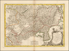
Rare Russian map of Alaska and the Northeastern part of Asia, published in Moscow in 1795.
This rare work is an early copy of Alexander Wilbrecht's monumental map of the northwest coast of America and northeastern parts of Russia, entitled Vostochnaya Chast Irtkutskoi Gubernii s prilezhashhimi ostrovami i zapadnom beregom Ameriki, which appeared in Wilbrecht's rare 1792 atlas entitled Ross'iiskoi Atlas iz soroka chetyrekh kart sostaiashch'ii I na sorok na dva namiestnichestva Imper'iiu razdieliaushch'ii and published in St. Petersburg.
The Maps of Alexander Wilbrecht
Wilbrecht's 1792 map drew from his 1787 Karta predstavliaiushchaia otkritii Rossiiskikh moreplavatelei na Tikhom More i aglinskago Kapitana Kukka. Although constructed on a different projection, the detail along the Alaska coastline is very similar to the 1787 map.
Alexander Wilbrecht was the most important mapmaker in Russia in the last decades of the 18th Century. Wilbrecht's second map of the Arctic regions between Asia and America and is generally regarded as the most important and detailed mapping of the Russian explorations, prior to Cook's arrival. The map includes information derived from the leading Russian explorers of the north Pacific: Bering, Chirikov, Krenitsyn, Shpanberg, Walton, Shelting and Petushkov, as well as incorporating knowledge from the 1778-79 voyage of British Captain James Cook and the discoveries of Alexander Mackenzie.
The map also appears to incorporate the explorations of Gerasim Ismailov, who after meeting Cook in 1778 and exploring the region in the 1780s, he discovered the Kenai Peninsula and information drawn from the Magnus Behm map. The map in the area of Kodiak Island is also contemporary to the explorations of Dimitrii Bocharov and Grigorii Shelikov but does not seem to include any information not found in Wilbrecht's earlier map.
Among its more interesting features, the map includes a detailed treatment of the topography of the Russian regions in northeast Asia and a remarkably detailed group of original Russian place names in Alaska and along the northwest coast of America. The map provides excellent detail in Alaska and along the northwest coast of America, reaching as far south as Northern California, a foreshadowing of the Russian attempts at colonization along the California coast.
Alexander Wilbrecht (1757-1823) was a mathematician, geographer, cartographer and astronomer. Wilbrecht served as Geographer of The Geographic Department of the Cabinet of Her Imperial Majesty. In 1782, he produced the first Russian atlas. He also produced a number of important separately issued maps between 1787 and 1802. Wilbrecht is credited with authorship of several atlases, including Ross'iiskoi Atlas iz soroka chetyrekh kart sostaiashch'ii I na sorok na dva namiestnichestva Imper'iiu razdieliaushch'ii [The New Atlas or a Collection of all parts of the Globe], St. Petersburg, 1793 (Philips 679).
The Ancelin-Le Grand Atlas of Russia
The present map appeared in a rare Russian atlas entitled General atlas et élementaire de l'Empire de Toutes les Russies: Divise en quarante deux gouvernemens avec deux supplements, Ouvrage fait d`après les Observations de l'Academie de St. Petersburg, Adapté aux geographes les plus modernes . . . , first published in 1795. The work included a general map and 45 double page regional maps of different parts of the Russian Empire as it existed at the end of the 18th Century.
In the map of Alaska, there is additional information added, including the routes of several early explorers including Captain James Cook (Clarke tracks) and most notably, two sets of tracks of Pavel Sergeyevich Lebedev-Lastochkin, one of which is dated 1777.
The tracks regarding the latter expedition is quite unusual. The note for the tracks reads "Voyage du pilote Petouches sur le bâtiment L'Hirondelle appartenant à Négociant Lebedef en 1777. Retour du même pilote à Okhotsk ( Translation: Voyage of Pilot Petouches on the ship L'Hirondelle belonging to Merchant Lebedef in 1777. Return of the same pilot to Okhotsk)."
Pavel Sergeyevich Lebedev-Lastochkin Attempts To Establish Trade Relations Between Russia and Japan
By the 1770s, the strategic importance of Kamchatka, Kuril Islands and Japan was becoming apparent to the Russian government. On May 11, 1772, Captain Magnus Earl von Bem was appointed commander of Kamchatka and instructed to conduct a covert expedition to the Kuril Islands and, if feasible, to Matsumae in Japan. Bem's mission included reconnoitering the islands under the guise of a fishing expedition, with instructions to engage with the Japanese and Kurilian inhabitants diplomatically.
Bem persuaded Irkutsk merchant Pavel Sergeyevich Lebedev-Lastochkin to sponsor the expedition. Lebedev invited Grigorii Ivanovich Shelekhov, founder of the Russian colonies in North America, to join as a partner. They prepared the ship Nikolai for a one-year voyage. On July 5, 1775, the Nikolai departed from Petropavlovsk but encountered a shipwreck at the eighteenth island (likely Urup). The trader Shabalin was dispatched to assist and brought supplies. By September 21, 1777, the brigantine Natalia, under the command of Pilot Petuchkov, safely reached Urup, but the harsh winter impeded further progress.
In June 1778, Shabalin, along with interpreter Ocheredin and thirty-two men, attempted to persuade the Kurilians to become Russian subjects. They met with Japanese traders on Atkis (likely Etorofu) and exchanged gifts, establishing a tenuous initial contact. On July 31, 1779, the Japanese requested the Russians return to confirm trade procedures. Persistent challenges, including a failed attempt to engage the Japanese on Kunashiri and a natural disaster on January 19, 1780, which saw earthquakes and a tidal wave devastate the expedition, hindered progress. Despite these setbacks, Shabalin continued efforts, and by February 8, 1781, a volcanic eruption further complicated matters.
In 1781, Antipin reported back to Irkutsk, detailing the expedition's difficulties. Recognizing the potential profitability of fur trading in the Kurils, numerous adventurers sought to exploit the islands. The complex geopolitics and the necessity for a fortified presence became evident. Lebedev returned to Irkutsk in 1781 and, after suffering significant financial losses, petitioned the governor for compensation and further support. The governor assigned the galleon Sviatoi Georgii, and Lebedev commissioned another ship, the Pavel, but continued failures, including the Pavel’s misdirection to the Aleutians, led to the cessation of his independent efforts.
Shelekhov and Lebedev are generally credited with launching the first Russian American Expedition. In 1783, Shelekov would go on to establish a settlement on Kodiak Island, probably the first permanent Russian settlement in North America. He parted ways with Lebedev that same year, when the latter launched an independent expedition and established settlements around Prince William Sound, overlooking Chugach Bay, east of the Kenai Peninsula. By 1795, only the firms of Shelekhov, Lebedev and Kisilev remained active in the Russian maritime fur trade in America.
Rarity
The map is extremely rare. This is the first example of the map we have seen on the market (1992-2024).
The map is not listed in OCLC and there is no record of the map appearing in RBH or AMPR.
We note examples of the complete atlas at Oxford, NYPL, Leiden, Munich, BNF and ULB Darmstadt.
![[Magellan's Strait] Exquisita & magno aliquot mensium periculo Lustrata et iam retecta Freti Magellanici Facies . . .](https://storage.googleapis.com/raremaps/img/small/94451.jpg)
![[Soviet Russian Ecology Propaganda Poster] Основы Водного Законодательства Союза ССР](https://storage.googleapis.com/raremaps/img/small/68343.jpg)
![(Mount St. Elias and Mt Fairweather to Cape Decision, Stika, Juneau and Prince Frederick Sound) Cote Nord-Ouest De L'Amerique Reconnue Par Cape. Vancouver Ve. Partie [Northwest Coast of America as recognized by Captain Vancouver, 5th Part]](https://storage.googleapis.com/raremaps/img/small/88128.jpg)