|
||

|

|
|

|
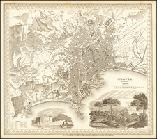
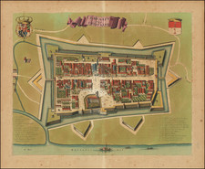
This late 16th Century plan of Pavia offers a detailed bird's-eye view of the city, identifying 125 place names in a key below. The map provides a comprehensive overview of the urban landscape, including significant buildings, streets, and geographic features.
This exquisitely detailed plan presents a comprehensive view of the city's layout during the late Renaissance period. Rendered in a bird's-eye perspective, the map meticulously identifies 125 place names in the key below, offering insights into the urban organization and notable landmarks of the time. The map highlights Pavia's strategic importance in Northern Italy, showcasing its intricate network of streets, fortifications, and significant structures such as churches, palaces, and public buildings. Notable landmarks include:
- Certosa di Pavia: The famous Carthusian monastery located just outside the city.
- University of Pavia: One of the oldest universities in Europe, established in 1361.
- Cathedral of Pavia (Duomo di Pavia): A significant religious building with a rich history.
- Basilica of San Michele Maggiore: An important example of Lombard-Romanesque architecture.
- Visconti Castle (Castello Visconteo): A prominent medieval fortress built by the Visconti family.
- Ponte Coperto (Covered Bridge): The iconic bridge spanning the Ticino River.
The city of Pavia, known for its rich history dating back to Roman times, was a significant center of commerce, learning, and military power in the Renaissance era. During the late 16th and early 17th centuries, Pavia's prominence was bolstered by its university, established in 1361, which attracted scholars from across Europe. The map reflects Pavia's fortified nature, indicative of its role in various conflicts and its strategic position along important trade routes.
![[Brixen, Italy and Lauingen, German] Brixia Tyrolis [and] Laubinga Sveviae](https://storage.googleapis.com/raremaps/img/small/76740.jpg)