


|
||

|

|
|

|
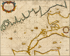
The First Map Dedicated to the Continent of North America [with] An Important Early Map of Scandinavia and the Baltic Region
Nice example of Bordone's maps of the East Coast of America and the mythical island of Brasile and Asmaide, with a map of Scandinavia and the Baltic on the verso, one of the earliest obtainable printed maps of each of the regions.
The map which includes the name "Terra de lavoratore" at the top center is generally regarded as the first map to focus solely on North America. Covering what was intended as the entirety of the east coast of North America, the map was drawn from early Spanish and Portuguese sources and includes several place names. The name "Terra de lavoratore" is based upon the Voyages of João Fernandes of the Azores, who travelled to Cape Farewell in Greenland in 1500). In addition to the New World, the Azores are named, as are the mythical islands of Brasile and Asmaide.
As described by Thomas Suarez in Shedding The Veil, this map indeed represents the entirety of North America, making it the first printed map solely dedicated to the continent. The map features a sea strait, labeled "Stretto," which divides North America from South America. When incorporating the isolated map of Lavoratore into Bordone's world map, as intended, this strait is situated at approximately 10 degrees North latitude. South of this strait lies the "Parte del Novo Mondo." The title "Terra de Lavoratore" originates from the nickname of João Fernandes, a Portuguese-Azorean adventurer who reached Greenland in 1500 and was known as "el lavrador." According to Suarez, Fernandes may have embarked on western voyages under the Portuguese flag as early as Columbus did under the Spanish flag.
The "Scandinavia & Baltic Map" perpetuates the myth that Greenland was attached to Scandinavia. The map locates a number of recognizable place names, including Norbegia (Norway), Gottia (Gothia), Livonia, Datia (Denmark), and Engronelant (Greenland). The Scandinavia map is still based on the shape of Nicolaus Germanus Donis.
Benedetto Bordone (1460-1531) was a manuscript editor, miniaturist, and cartographer, from Padua, in the Republic of Venice. His most famous work is the Isolario ( The Book of Islands, "where we discuss about all islands of the world, with their ancient and modern names, histories, tales and way of living...") in which he describes all the islands of the known world with their folklore, myths, cultures, climates, situations, and history. It is intended as an illustrated guide for sailors and attempts to include all the new transatlantic discoveries.
The text on the American map sheet describes the Land of Labrador, newly discovered by the Spaniards and Portuguese, noting as follows:
To this reasoning of mine, I will add the islands newly discovered by the Spaniards and Portuguese, among which there is one, named the Land of Labrador, which is located in the western ocean sea, to the northern part, and from Hibernia to the west, it is distant one thousand and eight hundred miles, extending westward two thousand miles and then turning south-west in such a way that it forms a channel with the new world, which is seen from east and west with the Strait of Gibraltar. And this part, which inclines, has a length of one thousand miles, and according to what navigators up to now have been able to understand from the islanders, because no person has been there, it is very well inhabited, and there are well-proportioned men, and in their appearance, they are gentle and shy, with their faces (like Indians) marked, some with six and some with eight signs, and more and less, as they prefer, dressed in the skins of various animals, but most of their garments are made of otter skins without any seams, and as they strip them from the animal, so they wear them. And in winter, they place the fur towards their flesh, and in summer, they do the opposite, but the parts that must be covered for modesty, they tie with very strong fish nerves. And dressed in this manner, they seem like wild men to see. These have their own language, they have no iron, but with some tools, they cut and shape their wood to make their buildings, which are made of very tall wood, and covered with fish skins, in such a way that they do not fear the water that falls from the sky. In this sea, there is such an abundance of fish, especially stockfish, salmon, and herring, that it is truly unbelievable, from which not only do men live but also wild animals, especially the bears, which enter the sea, walk on them, feed on them, and having eaten, with almost dry feet, return to the land. Here grow very tall pines, to make ship masts, and it is in the ninth climate at the twentieth parallel, and its longest day is eighteen hours.
Benedetto Bordone (1460-1531) was a polymath who was born in Padua and worked in Venice. He was an illuminator, engraver, miniaturist, editor, and geographer. It is possible he made the first globe in Italy. His most famous work is the Isolario, or Book of Islands, which included many of the earliest printed maps of islands in the New World.
Bordone, a prominent Venetian manuscript editor, miniaturist, and cartographer, was born in Padua, a city that was then part of the Republic of Venice. Although his exact date of birth remains unknown, historical records indicate that his parents married in Padua in 1442, and he himself was married in 1480. Bordone's contributions to the field of cartography, particularly through his seminal work, Isolario, have cemented his legacy as a pivotal figure in the Renaissance cartographic tradition.
Bordone's most renowned work, Isolario (The Book of Islands), printed in Venice in 1528, is a comprehensive compilation that describes all the known islands of the world. The book offers detailed accounts of each island's folklore, myths, cultures, climates, geographical situations, and historical narratives. It stands as a testament to the popularity of the isolario genre in 15th and 16th century Italy and serves as an illustrated guide for sailors, incorporating the era's latest transatlantic discoveries.
One of the notable features of Isolario is an oval depiction of the world, a map type invented by Bordone. This innovation was later formalized into the equal-area elliptical Mollweide projection three centuries afterward. Bordone's map portrays a distorted view of the New World, showing only the northern regions of South America and depicting North America as a large island labeled Terra del Laboratore (Land of the Worker), a likely reference to the region's active slave trade during that period, which also influenced the name Labrador.
The book also contains the earliest known printed account of Francisco Pizarro's conquest of Peru, making it a significant historical document. Among the numerous woodcut maps included in Isolario, twelve are dedicated to the Americas. These maps feature a plan of "Temistitan" (Tenochtitlan, modern Mexico City) before its destruction by Hernán Cortés, and a map of Ciampagu, the earliest known European-printed map of Japan depicted as an island.
Benedetto Bordone's familial connections are also of interest; he is reputed to have been the father of Julius Caesar Scaliger, a noted classical scholar, and the grandfather of Joseph Justus Scaliger, who is recognized as the founder of the science of historical chronology. The original maps from Bordone's Isolario are highly valued today for their historical significance and intricate craftsmanship. Through his work, Bordone has left an indelible mark on the history of cartography, providing invaluable insights into the geographical knowledge and cultural perceptions of his time.

![Mappa Królestwa Polskiego w dawnych granicach z oznaczeniem podziału w roku 1830... 1831 [Map of the Kingdom of Poland within its former borders with the designation of the division in the year 1830... 1831.]](https://storage.googleapis.com/raremaps/img/small/96457.jpg)

![Polonia Secondo le Osservazioni dell' Accademia di Parigi [Poland, according to the observations of the Paris Academy.]](https://storage.googleapis.com/raremaps/img/small/67787.jpg)