|
||

|

|
|

|
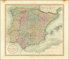
Updated edition of Guillaume Delisle's map of the Iberian Peninsula, engraved by Berey, with decorative cartouche by Simoneau.
The map illustrates the Iberian Peninsula in the middle of the 18th Century and bears the imprint of Philippe Buache, the heir to Guillaume Delisle's map publishing business, who by the 1740s had become one of France's most important mapmakers and geographers.
The Iberian Peninsula is divided into three major regions, The States of Portugal, States of Castille and Sates of Aragon, which are shown as including Catalunya and the Ballearic Islands.
Philippe Buache (1700-1773) was one of the most famous French geographers of the eighteenth century. Buache was married to the daughter of the eminent Guillaume Delisle and worked with his father-in-law, carrying on the business after Guillaume died. Buache gained the title geographe du roi in 1729 and was elected to the Academie des Sciences in the same year. Buache was a pioneering theoretical geographer, especially as regards contour lines and watersheds. He is best known for his works such as Considérations géographiques et physiques sur les découvertes nouvelles dans la grande mer (Paris, 1754).
![[ Lisbon and Cascais ] Lisbona. Olisipo ... vulgo Lisbona Florentissimum Portugalliae Emporiu. [with] Cascale Lusitaniae Opp](https://storage.googleapis.com/raremaps/img/small/96926.jpg)