|
||

|

|
|

|
Finely detailed pair of geological maps sheets covering all of California, published by the U.S. Geological Survey in Cooperation with the State of California.
The map shows California at the beginning of the Automobile Boom, shortly after close of World War II, as Americans began to explore the American West by car. Highways are designated in purple, with different symbols for US Highways and State Highways.
Topographical elevation contours are shown in brown, with rivers and lakes in blue. The size of the map allows for a comprehsive treatment of the towns, transit lines and other built features of the states.
The map is quite fascinating as a large scale representation of the transition of California from a mining, agriculture and timber driven economy of the late 19th and early 20th Century to more modern times, with many of the small towns which would become ghost towns or otherwise largely forgotten and places still shown in Eastern California.
The map sources listed in the image are:
- U.S. Dept. of the Interior - Geological Survey Topographic Maps
- U.S. Dept. of the Army - Corps of Engineers Topographic Maps
- U.S. Dept. of Agriculture - Forest Service Topographic Maps
- Geological Society of America - Submarine Topography of the Calif. Coast
- State of California - Divisions of Highways and Forestry Maps
- City of Los Angeles - Metropolitan Water Dist. Topo Maps

![[San Juan Capistrano to San Onofre] Capistrano Quadrangle](https://storage.googleapis.com/raremaps/img/small/83563.jpg)
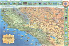
![[ Southern California ]](https://storage.googleapis.com/raremaps/img/small/98827.jpg)
![Map Showing the Summer Resorts on the Pacific Coast, adjacent to the lines of the Central and Southern Railroads. [California Tourist. Yosemite, The Big-Tree Groves Geysers, Monterey and other Popular Summer Resorts of Californa]](https://storage.googleapis.com/raremaps/img/small/41461.jpg)