


|
||

|

|
|

|
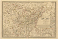
Monumental 1827 Wall Map of the United States, Canada and the "Province of Texas"
A quintessential large-format map from the 1820s, Walker's 1827 map of the United States stands as a monumental work, documenting interesting details in the Midwest and Plains Regions, including Native American tribes, several ephemeral forts and fur trading posts between the Missouri and Mississippi River Valleys.
Walker's map is a rare gem among early 19th-century English wall maps of the United States. While it draws heavily on David Vance's 1825 wall map published in Philadelphia, Walker's rendition surpasses the work of Vance, maintaining the same scale but significantly enhancing detail and accuracy.
The sheer scale and size of Walker's map surpass contemporary maps by John Melish and others, positioning it as arguably the most significant English-published map of the United States in the decades after Aaron Arrowsmith's map. The map features a double-wide Arkansas Territory and extraordinary detail west of the Mississippi River, and includes a comprehensive effort to delineate the counties in the Southern and Midwestern states.
Key features include the trader's route from Missouri to New Mexico, the Great Spanish Road, Road to the Pawnies, and early Western forts and settlements. The depiction of Michigan Territory, Illinois, Northwest Territory, and Missouri Territory, particularly the Missouri and Yellowstone Rivers, is unparalleled for this period.
One of the notable aspects of this map is its naming of "Fort Calhoun" on the Missouri River. The fort, located near the historical meeting place of Lewis & Clark and the Otoe Indians known as Council Bluff, first appeared on Major Long's maps from 1819-20. The fort was created by order of Secretary of War John Calhoun to protect the fur trade. Although absent from American military records, it was officially named "Fort Atkinson" in 1821, after its first commander. Fort Atkinson served the fur trade for eight years before being abandoned in 1827, with its garrison moving to Fort Leavenworth.
The map also pinpoints Fort Mandan, built by Lewis & Clark in November 1804 in present-day North Dakota. This site served as the expedition's winter quarters and was found burned and abandoned upon their return in 1806.
Another significant location identified on the map is "Indian Fort," situated on the Missouri River near modern Wolf Point, Montana, west of the confluence with the Yellowstone River.
Notably, the map also references the "Columbian Fur Co. Establishment" beyond the headwaters of the St. Peters River, near Lake Traverse. This establishment was the main trading post of the Columbia Fur Company, formed in 1822 by former employees of the North West Company following its merger with the Hudson's Bay Company. In 1827, around the map's publication, John Jacob Astor acquired the Columbia Fur Company, reorganizing it as the Upper Missouri Outfit, centered at the Mandan villages. Kenneth McKenzie led the Outfit, establishing Fort Floyd at the Yellowstone River's mouth, soon renamed Fort Union, which became a significant American post in the region. This move consolidated Astor's dominance over the Missouri River fur trade.
This map also offers an in-depth portrayal of the North West Company houses and factories, underscoring its historical significance and detailed craftsmanship.
In the southwest, the Province of Texas is shown, with the Presidios of Bejar and Bahia del Espiritu Santo noted, along with at least another dozen place names. Fort Matagorda, built by La Salle in 1685 is noted northwest of Galveston Bay. Native American Villages shown include Carancaways, Nadaco, "Panee" and "Haytones". On the northern bank of the Red River is "Cantonment Towson", an important U.S. army outpost, just west of the "Upper Settlements."
In all, one of the most detailed and comprehensive maps of the US published in the 1820s.
J. & C. Walker was the imprint used by the Walker family of engravers and printers. They produced numerous high-quality geographical maps and nautical charts for a variety of institutions in the nineteenth century. John Walker (1787-1873) held the position of Hydrographer to the East India Company, a position also held by his father and namesake. John worked in partnership with his brothers, Charles and Alexander. The brothers published over 200 maps for the Society for the Diffusion of Useful Knowledge. They produced maps for James Horsburgh and the Admiralty, as well as the influential Indian Atlas.
![(American Revolution - Spanish Mapping) Mapa Geografico Que Comprehende La Nueva Inglaterra, Nueva York, Nueva Jersey, Pensilvania, Maryland y Parte de Virginia. [Geographic Map Encompassing New England, New York, New Jersey, Pennsylvania, Maryland, and Part of Virginia.]](https://storage.googleapis.com/raremaps/img/small/95136.jpg)
![[Hand Drawn School Girl Map] United States](https://storage.googleapis.com/raremaps/img/small/67904.jpg)
