


|
||

|

|
|

|
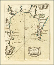
Scarce map illustrating the strategic layout of Gibraltar Bay during the Anglo-Spanish War (1727-1729). It specifically covers the period of the siege of Gibraltar from February 11 to June 12, 1727, where the Spanish forces, commanded by Cristóbal de Moscoso y Montemayor, laid siege to the British garrison. The British forces were supported by the navy under Admiral Sir Charles Wager. The map is oriented with south at the top, as indicated by the compass rose.
The map details the sea assault conducted by Sir Charles Wager and shows the positions of the Spanish camps. It provides a comprehensive view of the coastline from east of Gibraltar to south-west of Cap Cabrero. Key features include the anchoring positions, soundings in fathoms, and notable landmarks such as the Point of Europe and the Plains of San Roque.
![[ Gibraltar ] Plan Topo-Hydrographique de la Baye de Gibraltar](https://storage.googleapis.com/raremaps/img/small/74381.jpg)
![[ Gibraltar ] Plan du promontoire de la ville et du port de Gibraltar avec les ouvrages faits depuis le dernier siège et les lignes construites par ordre de sa Majesté très catholique, pour empescher la communication de Gibraltar avec l'Espagne : levé nouvellement sur les lieux par l'ingenieur de la place.](https://storage.googleapis.com/raremaps/img/small/98510.jpg)
![Neuester und exacter Plan und Prospect von der Stadt Vestung Bay und Fortification Von Gibraltar…1733 [with view of Cadiz]](https://storage.googleapis.com/raremaps/img/small/91413.jpg)