|
||

|

|
|

|
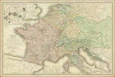
Western Europe after the Napoleonic Wars and the Congress of Vienna.
Rare third edition of Eustache Hérisson's four-sheet geographical and administrative map of the Kingdom of France and its neighboring regions, including parts of the German states and Italy. The map was revised and augmented by Adrien Hubert Brué, a prominent geographer of the time, for his Grand Atlas Universel ou Collection de Cartes Encyprotypes.
This map of France and Western Europe from 1816 encapsulates a transformative period in European history following the Napoleonic Wars. After Napoleon's defeat at the Battle of Waterloo in 1815, the Congress of Vienna (1814-1815) reconfigured European borders, restoring monarchies and establishing a new political order to maintain stability. In France, King Louis XVIII's Bourbon Restoration marked the end of the First French Empire, but retaining Napoleon's reorganization of the country into departments. The map reflects the new political boundaries and administrative divisions set by the Congress, emphasizing the restored borders of the Kingdom of France and its place in Western Europe. This period saw conservative efforts by the Holy Alliance to suppress revolutionary movements and maintain the status quo, with Britain emerging as a dominant global power. Cartographic advancements in surveying and printing technology during this era resulted in more accurate and detailed maps, illustrating France's administrative structure and the broader European geopolitical landscape.
The map is notable for its hand-colored details, which distinguish between various minute political entities. It includes several important sections:
-
États de l'Allemagne: This section lists the various German states, such as the Empire of Austria, the Kingdom of Prussia, the Grand Duchy of Baden, and others. Each state is color-coded for easy identification. The map also details the mediatised states within the old circle of Westphalia, listing principalities and counties under Prussian protection.
-
États de l’Italie: Similar to the German section, this part of the map provides a breakdown of the Italian states, including the Kingdom of Sardinia and the Duchy of Genoa, the Kingdom of Naples, and others, with distinct color coding.
-
Divisions Militaires et leurs Chefs-Lieux: This section details the military divisions and their chief towns within France, organized by departments and regions.
In addition to these primary sections, the map encompasses an extensive area, including the Kingdom of the Netherlands, Switzerland, parts of the Austrian Empire, and various Italian duchies. It extends as far as the Adriatic coast and even includes an in set of the Ionian Islands.
The map was published by Desray, a noted bookseller and publisher, and J. Goujon, a dealer in geographical maps.
Andre Hubert Brué was a French geographer and cartographer. Born in Paris, he served in the French Navy, joining the Baudin expedition to the Pacific (1800-1804). After his sea service, Brué applied his navigation and charting skills to creating finely-crafted maps, which were renowned for their crisp engraving and accuracy. He drew directly on the copper of the plate, creating what he called encyprotypes. He is best known for the Atlas universal de géographie physique, politique, ancienne et moderne.
![[ France ] Galliae seu Franciae Tabula, qua omnes Provinciae, Viae angiariae, et aliae res notatu dignae distincte et accurate ostenduntur . . .](https://storage.googleapis.com/raremaps/img/small/98436.jpg)
![[ WWI Anti-German Propaganda ] Le Plan Pangermaniste](https://storage.googleapis.com/raremaps/img/small/63622.jpg)
![[Anne Du Bourg Confront the King Henri II and the Parliament of Paris in June 1559] Der Parlements hern gem in rath Mercu rialle gen ant bein Kugusinern ou Paris. . .](https://storage.googleapis.com/raremaps/img/small/78594.jpg)