|
||

|

|
|

|
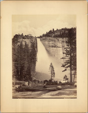
This topographic map of Yosemite Valley in Mariposa County, California, was produced by the U.S. Geological Survey under the direction of George Otis Smith. The map was created in cooperation with the State of California, with key figures including Governor George C. Pardee, Secretary of State C.F. Curry, and Attorney General U.S. Webb. The topography was mapped by F.E. Matthes, with E.M. Douglas serving as the geographer and R.B. Marshall in charge of the section. Triangulation was performed by C.F. Urquhart. Surveyed in 1905-1906, this map edition is dated July 1907 and was reprinted in June 1909. The map features contour lines with a 50-foot interval, detailed elevations, and various geographical features such as rivers, creeks, cliffs, and peaks. Notable points of interest include Half Dome, El Capitan, Glacier Point, and Yosemite Falls. The map includes a key for the elevations of principal points and a small inset map indicating the position of the Yosemite Valley within California. The scale of the map is 1 inch to 2000 feet (1:24000).
The map was used by the amateur geographer Colonel George Ruhlen to map historical features around Yosemite. These are recorded in his manuscript annotations and include Camp Curry and Fort Monroe.
Provenance
Colonel George Ruhlen (1884-1971), noted Southern California historical geographer.
![(Mammoth Plate Photograph) [El Capitan, Yosemite]](https://storage.googleapis.com/raremaps/img/small/88268.jpg)
![(Yosemite Photographs) [Contemporary Album of 12 Albumen Photographs of Yosemite Valley] Views in California [binding title]](https://storage.googleapis.com/raremaps/img/small/94232.jpg)
![Map Showing the Summer Resorts on the Pacific Coast, adjacent to the lines of the Central and Southern Railroads. [California Tourist. Yosemite, The Big-Tree Groves Geysers, Monterey and other Popular Summer Resorts of Californa]](https://storage.googleapis.com/raremaps/img/small/41461.jpg)
![(Mammoth Plate Photograph) [View on the Merced, Yosemite]](https://storage.googleapis.com/raremaps/img/small/88250.jpg)