|
||

|

|
|

|
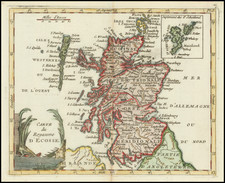
This map, created by Willem Janszoon Blaeu, depicts the historical region of Lennox, or Dumbartonshire, in Scotland. The map is richly adorned with a decorative cartouche in the bottom left corner, featuring figures and heraldic elements that add to its aesthetic appeal. The geographical details include mountains, rivers, forests, and settlements, rendered with precision characteristic of Blaeu's work.
The main city marked in red is Dumbarton. Key bodies of water featured on the map include the River Clyde, flowing through the southern part of the region; Loch Lomond, a large freshwater loch situated in the north; and the River Leven, connecting Loch Lomond to the River Clyde, passing through Dumbarton.
Willem Janszoon Blaeu (1571-1638) was a prominent Dutch geographer and publisher. Born the son of a herring merchant, Blaeu chose not fish but mathematics and astronomy for his focus. He studied with the famous Danish astronomer Tycho Brahe, with whom he honed his instrument and globe making skills. Blaeu set up shop in Amsterdam, where he sold instruments and globes, published maps, and edited the works of intellectuals like Descartes and Hugo Grotius. In 1635, he released his atlas, Theatrum Orbis Terrarum, sive, Atlas novus.
Willem died in 1638. He had two sons, Cornelis (1610-1648) and Joan (1596-1673). Joan trained as a lawyer, but joined his father’s business rather than practice. After his father’s death, the brothers took over their father’s shop and Joan took on his work as hydrographer to the Dutch East India Company. Later in life, Joan would modify and greatly expand his father’s Atlas novus, eventually releasing his masterpiece, the Atlas maior, between 1662 and 1672.
![Scotia Antiqua, qualis pricis temporibus Romanis praesertim, Cognita suit quam in lucem eruere conabatur R Gordonius a Straloch M DC LIII [Ancient Scotia, as it was known in earlier times, particularly to the Romans, attempted to be brought to light by R. Gordonius of Straloch in 1653.]](https://storage.googleapis.com/raremaps/img/small/93094.jpg)