


|
||

|

|
|

|
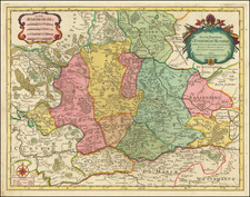
Detailed regional map of Lusatia, with two decorative cartouches and smaller coat of arms.
The map Lusatia Superior, attributed to Bartholomaeus Scultetus, illustrates the region of Upper Lusatia in the mid-17th century, with Görlitz prominently featured. This historical cartographic artifact provides a detailed depiction of the towns, villages, rivers, and topographical features of the area, reflecting its significant historical and geopolitical context during a tumultuous period in European history.
Lusatia, historically divided into Upper and Lower Lusatia, has been a significant and contested region in Central Europe. During the time this map was created, Lusatia was under the influence of the Holy Roman Empire, but its control and affiliation shifted among various powers due to its strategic importance. The Thirty Years' War (1618–1648) profoundly impacted the region, contributing to its political instability and demographic changes.
Görlitz, as depicted on the map, was a major urban center in Upper Lusatia. The city's location on the Neisse River made it a critical hub for trade and commerce, linking Saxony with Silesia and
Upper Lusatia's unique cultural and linguistic diversity included influences from German, Sorbian, and Polish communities.
Willem Janszoon Blaeu (1571-1638) was a prominent Dutch geographer and publisher. Born the son of a herring merchant, Blaeu chose not fish but mathematics and astronomy for his focus. He studied with the famous Danish astronomer Tycho Brahe, with whom he honed his instrument and globe making skills. Blaeu set up shop in Amsterdam, where he sold instruments and globes, published maps, and edited the works of intellectuals like Descartes and Hugo Grotius. In 1635, he released his atlas, Theatrum Orbis Terrarum, sive, Atlas novus.
Willem died in 1638. He had two sons, Cornelis (1610-1648) and Joan (1596-1673). Joan trained as a lawyer, but joined his father’s business rather than practice. After his father’s death, the brothers took over their father’s shop and Joan took on his work as hydrographer to the Dutch East India Company. Later in life, Joan would modify and greatly expand his father’s Atlas novus, eventually releasing his masterpiece, the Atlas maior, between 1662 and 1672.
![[ Baltic Sea / Sweden / Poland / Rugen ] De Custen van Denemarcken en Sweden, van Valsterbon tot Schenkenes, als mede de cust vanten van Pomeren van't eylant Rugen tot Rygshooft . . .](https://storage.googleapis.com/raremaps/img/small/99944.jpg)
![[Western Poland / Northeastern Germany] Lusatia Superior Ex Officina Davids Funck Norimbergae](https://storage.googleapis.com/raremaps/img/small/91153.jpg)
![Holsatiae Descriptio [with] Rugiae Usedomiae et Iulinae Wandalicarum insularum Vera descrtiptio 1584](https://storage.googleapis.com/raremaps/img/small/83746.jpg)
![[ Brandenburg & Pomerania ] Tabula Electoratus Brandenburgici, Meckelenburgi et Maximae Partis Pomeraniae . . . 1630](https://storage.googleapis.com/raremaps/img/small/99232.jpg)