|
||

|

|
|

|
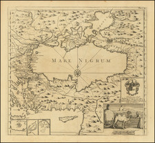
This detailed map of the Black Sea, referred to as Mare Nigrum, showcases the surrounding regions including parts of modern-day Turkey, Ukraine, and Eastern Europe. The map features geographical and topographical details such as mountains, rivers, and cities. The engraving includes a decorative cartouche and an inset with illustrations of local life, including a camel pulling a yurt. The map includes three insets depicting the regions of Santorini, Alexandria, and Tripoli.
The intricate details and cultural depictions provide a comprehensive view of the Black Sea region during the time of Aubrey de la Motraye's travels.
The map appeared in A. de la Motraye's Travels Through Europe, Asia, and into Part of Africa, a lengthy travel account by Aubry de La Motraye. The three-volume set documents La Motraye's extensive travels across Europe, Asia, and parts of Africa during the late 17th and early 18th centuries. The first two volumes were published in 1723, and a third volume was added in 1732.
![[ Ethnographic Thematic Atlas - Poland, Lithuania, Ukraine, etc. ] Völker-Verteilung in West-Russland (Distribution of Peoples in Western-Russia)](https://storage.googleapis.com/raremaps/img/small/94045.jpg)
![The Severn or Channel of Bristol [with a chart of the Irish Sea.]](https://storage.googleapis.com/raremaps/img/small/47485.jpg)