|
||

|

|
|

|
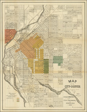
Large Map of Colorado From One Colorado's Most Important 19th Century Mapmakers
Morris Bien Copy
Scarce 1889 edition of Nell's map of Colorado. A remarkably detailed map, certainly the most complete of Colorado to appear after statehood (1876).
The map meticulously depicts the geographical and topographical details of the state, including mountain elevations. Wagon roads, trails, and railroads both existing and proposed are depicted. Counties are shown in different colors. Nell worked on the 1871-1879 Wheeler Surveys and gained a significant amount of information from this work, which he ultimately employed in producing what is without doubt the best large format map of the state of the period and became a huge commercial success.
Nell notes Railroads, proposed Railroads, Wagon Roads, proposed Wagon Roads, Trails, County Seats, Post Offices, Villages, Townships subdivided and surveyed, Contour lines, Military Reservations, Private Grants, areas of each county, astronomical positions, arable lands, and a host of other details.
Nell succeeded Thayer as the most important map maker in Colorado and continued publishing maps until the early 1900s. An essential map for Colorado collectors.
Morris Bien
Morris Bien was active from the 1880s onward as a topographer and later as an important figure in Western water and irrigation rights in the early part of the 20th Century. In the period after the map's publication, he was involved in a survey of the Aspen area for the US Geological Survey.
![[DeWitt Clinton Copy] An Account of Expeditions to the Sources of the Mississippi, and through the Western Parts of Louisiana, to the Sources of the Arkansaw, Kans, La Platte, and Pierre Jaun, Rivers During the years 1805, 1806 and 1807. And a Tour through the Interior Parts of New Spain. in the year 1807.](https://storage.googleapis.com/raremaps/img/small/81745.jpg)