|
||

|

|
|

|
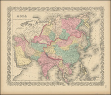
Large antique four-sheet wall map of Asia, by Hubert Brué, one of his "Carte Encyprotype" series, first issued in 1814.
The map is exceptionally detailed and is comparable to Aaron Arrowsmith's work in its quantity of information and quality of engraving. The map covers the Ottoman Empire, Arabia, the detailed and complicated borders of India, impressive detail in Siberia and the internal provinces of China, the Philippines, and East Asia.
Brue's 1814 four-sheet map of Asia stands as a monumental work in the field of early 19th-century cartography, synthesizing a wide array of contemporary sources to depict the continent with unprecedented accuracy and detail. This map highlights Brue's dedication to integrating diverse geographic information from explorers, surveyors, and previously published maps. This essay explores the primary sources and methodologies used by Brue, shedding light on the meticulous process behind the creation of this significant map.
- Northern Asia: Siberia and Russian Territories
For Siberia and adjacent Russian territories, Brue relied heavily on the maps published by the Russian Depot of Charts in St. Petersburg, especially those from 1809. These sources provided detailed geographic information for regions extending from the western limits of Russia to the eastern boundaries of Asia, including the Arctic coast and the Bering Strait. The explorations of Admiral Sarytscheff and the accounts of Krusenstern were pivotal, offering precise latitude and longitude data.
- Central Asia: Russian America and Kamchatka
The mapping of Russian America and the Kamchatka Peninsula was informed by the voyages of Sarytscheff and additional sources detailing the geography of these remote areas. The work included comprehensive coverage of regions up to the 63rd degree of longitude west from Paris and the 60th degree of latitude, encompassing Alaska, the Aleutian Islands, and the coastal areas of the Pacific Northwest.
- Southern Asia: Arabian Peninsula and Persian Gulf
For the Arabian Peninsula and the Persian Gulf, Brue utilized various sources, including the maps by Admiral Rodney and the observations from Lord Valentia's voyages. These provided critical insights into the Red Sea coast and the internal regions up to the Cape Bab-el-Mandeb and Cape Rasalgate. The inclusion of Mannelville's charts and Dalrymple's maps enhanced the accuracy of these coastal depictions.
- Central and Western Asia: Persia and the Caucasus
The detailed representation of Persia (modern-day Iran) and the Caucasus region drew from Chardin's travels and additional maps by D'Anville and Wahl. These sources contributed to a comprehensive understanding of the political and geographical boundaries, as well as the cultural landmarks within these regions.
- Eastern Asia: China, Korea, and Japan
Brue's depiction of China, Korea, and Japan was heavily influenced by the works of prominent cartographers such as D'Anville and Arrowmith, supplemented by the travel accounts of Krusenstern and Broughton. These sources provided essential data on the complex geography and political landscape of Eastern Asia, including the islands and coastal areas.
- Southeast Asia and Oceania
The mapping of Southeast Asia, Australasia, and Polynesia integrated data from various explorers and cartographic works, particularly those included in Brue's map of Oceania, which was part of his broader effort to chart the entire known world.
Andre Hubert Brué was a French geographer and cartographer. Born in Paris, he served in the French Navy, joining the Baudin expedition to the Pacific (1800-1804). After his sea service, Brué applied his navigation and charting skills to creating finely-crafted maps, which were renowned for their crisp engraving and accuracy. He drew directly on the copper of the plate, creating what he called encyprotypes. He is best known for the Atlas universal de géographie physique, politique, ancienne et moderne.
![I. a [Asia]](https://storage.googleapis.com/raremaps/img/small/93297.jpg)