


|
||

|

|
|

|
Stock# 105418
Description
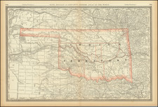
Rare separately published map of Oklahoma, with two decorative vignettes. Early edition, which seems to have been first printed about 1909.
Shows Capital, County Seats, Townships & Settlements, Oil Pipe Lines, Gas Pipe Lines, Electric Lines, Cotton Compresses, Cotton Factories, Stations with agents, sidings and spurs, and a color coded list of 14 railroads.
Condition Description
Segmented and laid on linen, with original covers.
![(Texas - Comanche Indian Photograph) Tush=a=wa or Whiteknife, Pen=a=teth=ka, Comanche Chief [Cabinet card photograph of Tosahwi, White Knife, or Tosawa; Penateka Comanche Chief]](https://storage.googleapis.com/raremaps/img/small/93032.jpg)
![[Original photograph:] Outdoor council of Native Americans, possibly Cheyenne and Arapaho in Indian Territory](https://storage.googleapis.com/raremaps/img/small/78743.jpg)
![[Oklahoma City] Section 22 - T.IIN.-R.3W. Oklahoma City OIl Field](https://storage.googleapis.com/raremaps/img/small/83380.jpg)