|
||

|

|
|

|
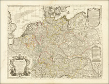
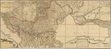
A Rare Italian Carte-a-figures Map of the Holy Roman Empire
Rare separately published map of the Holy Roman Empire, published by Francesco Sabatini in Bologna.
This intricately detailed map of the Holy Roman Empire, likely from the late 17th century, exemplifies the cartographic and artistic standards of its time. The map is surrounded by richly illustrated borders depicting prominent figures and cities, reflecting the political and social landscape of the era. This map was modeled after an earlier work by Pieter van den Keere and dedicated to Enea Silvio Caprara (1631-1701), a native of Bologna and an officer serving the imperial house in Vienna. The dedication aligns with Caprara's rank in the early 1670s, suggesting Sabatini's awareness of his patron's prestigious position.
The top border features portraits of the Electors of the Holy Roman Empire, each depicted on horseback, emphasizing their noble status and martial prowess. From left to right, these are:
- Archbishop of Mainz (Archiepiscopus Moguntinus)
- Archbishop of Cologne (Archiepiscopus Coloniensis)
- Archbishop of Trier (Archiepiscopus Trevirensis)
- King of Bohemia (Bohemiae Rex)
- Count Palatine of the Rhine (Palatinus Comes Rheni)
- Duke of Saxony (Dux Saxoniae)
- Margrave of Brandenburg (Marchio Brandenburgensis)
Along the left and right borders are depictions of various Germanic noble figures, each representing different aspects of the noble and administrative classes within the Empire. These include:
- Nobili Germaniae
- Hallei Norwegiorum
- Maior Militum
- Fuitores Germaniae
- Habitu Helvetii
- Publica Germaniae
The bottom border features picturesque views of significant cities within the Holy Roman Empire, offering a visual tour of some of the most important urban centers of the time. From left to right, these cities are:
- Hamburg (Hamburgum)
- Leipzig (Lipsia)
- Prague (Praga)
- Nuremberg (Norimberga)
- Augsburg (Augustae)
- Regensburg (Ratisbona)
- Cologne (Colonia)
Rarity
All Sabatini maps are of the utmost rarity.
OCLC locates 1 example (University Library of Erlangen-Nürnberg)
Francesco Sabatini, also known as Franciscus Sabadinus, remains a somewhat obscure figure in the realm of Italian map publishing during the sixteenth and seventeenth centuries. The precise details of his life and work are still subjects of ongoing research.
Evidence suggests that he was active as a printer, publisher, and possibly engraver in the 1670s, likely based in Bologna, and was the publisher of several maps by Pietro Todeschi which do not bear Sabatini's name.
Sabatini is known for three exceptionally rare maps, each featuring dedications signed by him. These maps reflect his engagement with contemporary cartographic models and prominent figures of his time:
-
Map of the Holy Roman Empire: This map was modeled after an earlier work by Pieter van den Keere and dedicated to Enea Silvio Caprara (1631-1701), a native of Bologna and an officer serving the imperial house in Vienna. The dedication aligns with Caprara's rank in the early 1670s, suggesting Sabatini's awareness of his patron's prestigious position.
-
Map of the Netherlands: This map was based on a model published in 1672 in Rome by François Collignon. It was dedicated to Francesco del Giudice (1647-1725), who served as a legate of the Holy See in Bologna during the early 1670s. Sabatini's choice of dedicatee reflects his connections with influential ecclesiastical figures.
-
Map of the Iberian Peninsula: Also derived from a model by Pieter van den Keere, this map was dedicated to the Bologna patrician Bartolomeo Manzoli († after 1676). Notably, the map includes a portrait of King Charles II of Spain (1661-1700), depicted as a child, indicating its creation during the early years of Charles's reign.
These maps exemplify Sabatini's contribution to the cartographic traditions of his time, demonstrating his ability to blend contemporary geographical knowledge with the demands and tastes of his distinguished patrons.
![Venezia Tridentina [and] Venezia Giulia](https://storage.googleapis.com/raremaps/img/small/97892.jpg)