


|
||

|

|
|

|
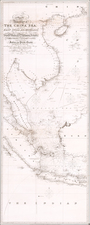
Published in Amsterdam as part of the Atlas Minor, this 1632 map by Johannes Cloppenburg offers an early glimpse into the cartographic understanding of China and Korea during the early 17th century. Based on the work of Jodocus Hondius and engraved by Petrus Kaerius, the map reveals the period's geographical misconceptions and mythologies.
The map illustrates Japan without Hokkaido, reflecting incomplete knowledge of the archipelago. Korea is presented as a misshaped island rather than a peninsula, a common error in early European maps. China's northern boundary is marked by the Great Wall, emphasizing its role as a defining geographical and cultural barrier. Notably, China is shown with large, fictitious lakes and randomly scattered mountains, embodying a blend of real and imagined topographical features. The map also perpetuates an ancient myth of a large lake being the source of many rivers in Southeast Asia, a belief that persisted in European cartography for centuries.
At the western end of the map, Eastern India is depicted with multiple cities and rivers flowing into the Bay of Bengal. The depiction includes an unusual and incorrect perception that the Ganges River's source lies in a region far north and somewhat west of China’s Great Wall. This significant geographical inaccuracy highlights the limited and speculative nature of contemporary European knowledge about South Asia's river systems.
The map extends to include parts of present-day Alaska, shown as separated by the Anian Strait. This representation reflects the period's exploratory fervor and the prevailing belief in a navigable passage linking the Pacific and Atlantic Oceans. The Anian Strait, a mythological waterway, symbolizes the hopes and uncertainties of early cartographers attempting to chart the vast and largely unknown northern reaches of the world.
Johannes Cloppenburg (sometimes Cloppenburgh; also H. Jan Evertsz and Johannes Everhardus) was a Dutch cartographer. Based in Amsterdam, he was active between roughly 1610 and 1644. He worked closely with the Hondius/Jansson firm and is credited with the 1630 edition of the Atlas Minor.
![[ Hong Kong / Macao / Canton ] Iunnan, Queicheu, Quangsi et Quantun, Provinciae Regni Sinensi Praefecturae dictae](https://storage.googleapis.com/raremaps/img/small/55800.jpg)
![[Illustration of Foreign Attendants] [lkoku-jin zuishin no zu]](https://storage.googleapis.com/raremaps/img/small/55556.jpg)