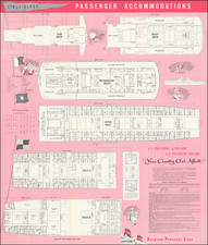
|
||

|

|
|

|
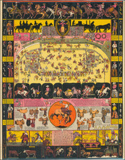
Rare old color flag chart, published by Mathaeus Seutter.
The chart illustrates 139 flags of various nations, factions, and trading companies, including the flags of China (bottom center) Dutch West India Company (Geoctroyeerde Westindische Compagnie) and the Dutch East India Company (V.O.C), two Chinese flags and two Tartar flags.
At bottom center the flag of Empire of China appears as a great whirlpool surrounded by eight decorations. This is most likely based upon an image of the Chinese flag appearing in Carl Allard's, 1705 Dutch flag book, Niewe Hollandse Scheeps Bouw. In fact, it is a misinterpretation of the Qing flag, a dragon on a yellow field with eight banners. However, European mapmakers, likely having never seen a Chinese flag, interpreted the dragon to the best of their ability.
Matthäus Seutter (1678-1757) was a prominent German mapmaker in the mid-eighteenth century. Initially apprenticed to a brewer, he trained as an engraver under Johann Baptist Homann in Nuremburg before setting up shop in his native Augsburg. In 1727 he was granted the title Imperial Geographer. His most famous work is Atlas Novus Sive Tabulae Geographicae, published in two volumes ca. 1730, although the majority of his maps are based on earlier work by other cartographers like the Homanns, Delisles, and de Fer.
Alternative spellings: Matthias Seutter, Mathaus Seutter, Matthaeus Seutter, Mattheus Seutter
![[Charles Lindbergh] Spirit of St. Louis](https://storage.googleapis.com/raremaps/img/small/69234.jpg)
![[World Map / Malaria / Dr. Seuss ] This is Ann . . . She drinks blood!](https://storage.googleapis.com/raremaps/img/small/73499.jpg)