|
||

|

|
|

|
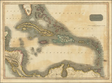
Still "Just" A Territory!
One of the earliest obtainable maps of Florida Territory, which (despite the title) predates statehood by some 13 years, a curious error a British map.
The map is also quite possibly the earliest printed map of Florida Territory to have been published in Great Britain, pre-dating by 1 year the SDUK map of Florida.
The south is dominated by Monroe County, Mosquito County and a massive area listed simply as Seminole Indians. Alachua, St. Johns, Nassau, Duval, Madison, Jefferson, Leon, Gadsden, Walton, Jackson, Escambia, and Washington are the only other counties, for a total of 15 counties in the state.
A few early roads are shown. Early towns are noted. The lake, river and swamp system is still quite primitive. Good detail in the Keys.

![(18th-Century Southern Borderlands) [Collection of manuscript letters to Secretary of War James McHenry from confidential U.S. agent John McKee, relating to southern borderlands, Native Americans and Panton, Leslie & Co.; a letter from John McKee written from Mobile, Alabama, to William Blount of Blount's Conspiracy fame; a letter from William Panton concerning John McKee; and letters from Felix D. St. Hilaire, concerning General Victor Collot]](https://storage.googleapis.com/raremaps/img/small/90005.jpg)