|
||

|

|
|

|
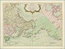
Rare Post-Louisiana Purchase / Pre-Lewis & Clark Map of North America
Rare map of North America issued just 3 years after the Louisiana Purchase and including a fascinating look at the Northwest Passage.
The map is noteworthy for a host or reasons. It provides a marvelous depiction of the vast unknown region beyond the known extent of the Missouri River, pre-dating the return of Lewis & Cark. The depiction of the Northwest Coast of America and the northern parts of Alaska and the Northwest Passage are both meticulously detailed and unique in the shape of the coastline.
The map depicts significant detail in Texas for the period. Georgia runs to the Mississippi River, as does a massive West Florida, on the eve of its purchase by the US from Great Britain.
There are a number of fascinating regions located, including Juinaer-Land (Illinois), Missurier-Land, Tschipiwaerland, etc. Fort Sinclair, Fort Detroit and Ft. St. Joseph appear in Michigan Territory, which is as yet unnamed. The place names in California are dominated by the Missions, but a few other place names are located. Excellent detail in Russian America.
The map includes a note stating "Der westlichste Punkt wohin Vandriet 1791, gekommen," referring to John Cornelius Vandriel (Van Driel), a North West Company clerk stationed at Ile-a-la-Crosse in 1788-89 and Athabasca in 1789-90. Vandriel, who likely learned surveying from MacKenzie, was sent to make surveying observations on the road to the Grand Portage in 1790. After leaving the North West Company, he worked for the Hudson Bay Company for five years, traveling as far as Cumberland House.
Rarity
The map is apparently very rare.
![[Important Early Geology Maps] Tableau du Climat et du Sol des Etats-Unis D'Amérique. Suivi d'éclaircissemens sur la Floride, sur la colonie Française au Scioto, sur quelques Canadiennes et sur les Sauvag . . .](https://storage.googleapis.com/raremaps/img/small/69358.jpg)
![(American Revolution) Geschichte der Revolution von Nord-America. Sammlung der besten Schriftsteller, welche die Geschichte, besondere Rechten, Sitten, und Gewohnheiten der Völker nach ihren Grundsätzen abgehandelt haben [with map:] Die Vereinigten Staaten von Nord=America. nach der Wm. Faden 1783. [History of the Revolution of North America. Collection of the Best Writers Who Have Discussed the History, Specific Laws, Customs, and Habits of the Peoples According to Their Principles [with map:] The United States of North America. According to Wm. Faden, 1783.]](https://storage.googleapis.com/raremaps/img/small/90124.jpg)