|
||

|

|
|

|
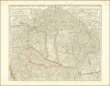
This extremely rare map, created circa 1680 by Jacob Sandrart, a renowned engraver and mapmaker based in Nuremberg, presents a comprehensive depiction of Southern Europe, including Greece, Italy, Anatolia (modern-day Turkey), Hungary, and the Danube River region.
Jacob Sandrart, active during the latter half of the 17th century, was celebrated for his detailed and artistic cartographic works, which often combined geographical accuracy with elaborate artistic embellishments.
The map encompasses a vast region of Southern Europe and the Eastern Mediterranean. It extends from Italy in the west to Anatolia in the east, covering significant portions of the Balkans and Central Europe, including Hungary and the entire course of the Danube River. The map highlights the complex network of territories and principalities that characterized the region during this period, including the Ottoman Empire's dominions in the east and the Holy Roman Empire's territories in Central Europe.
During the late 17th century, the geopolitical landscape of this region was marked by significant conflicts and shifting alliances. The Ottoman Empire was at its zenith, exerting control over much of Southeastern Europe, including parts of Hungary, Greece, and the Balkans. In contrast, the Holy Roman Empire, various Italian states, and other European powers were engaged in continuous struggles to check Ottoman expansion and maintain their own influence. The map reflects the complex and fragmented political boundaries of the era, with numerous small states and principalities delineated within the broader empires.
The map's allegorical cartouche, located in the bottom left corner, is a striking example of the baroque style typical of the period. It features elaborate imagery and symbolism, with figures representing the regions depicted on the map. On the left, a figure in classical attire gestures towards the map, symbolizing knowledge and discovery. Adjacent to him, a soldier with a shield adorned with a cross represents the Christian realms of Europe, contrasting with the Ottoman figures on the right, who are depicted with traditional Ottoman military attire, including turbans and curved swords. Above, a collection of flags, weapons, and a helmet symbolize martial power and the ongoing conflicts of the era. The cartouche also includes various instruments of cartography, such as compasses and globes, emphasizing the scientific and artistic endeavors of mapmaking. At the foot of the Europeans is a disembodied head.
Rarity
The map is extremely rare on the market. We have located a single example at auction in the past 20 years and a single example in a dealer catalog.
![[ Postal Map of Eastern Europe ] Deutschlands Postkarte begraenzt von Oesterrreich, Preussen, Frankreich, Holland, Italien und der Schweiz. Gezeichnet und Herausgegeben von Ignaz Heymann. K.K. Obserpostamtsoffizier in Trieste. 1800.](https://storage.googleapis.com/raremaps/img/small/77678.jpg)
![(Sea Atlas of the Mediterranean) Guida fedele de piloti per il mare Mediterraneo. [Faithful Guide for Pilots for the Mediterranean Sea.]](https://storage.googleapis.com/raremaps/img/small/104783.jpg)
![[ Bosnia ] Izlozba Drazavni Osiguravajua Zavod Direkcija za nr Bosnui Hercegovinu (Exhibition of The Insurance Institute Directorate of Bosnia Herzagovina)](https://storage.googleapis.com/raremaps/img/small/50706.jpg)