


|
||

|

|
|

|
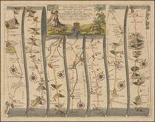
An impressive example of Dury and Andrews's colossal map of southeast England encompassing the area around "65 Miles Round" London; in the southwest getting as far as Portsmouth and the east part of the Isle of Wight; in the northwest extending past Oxford to Banbury; in the northeast to Ipswich, Harwich and the River Stour; and in the southeast the coasts of Kent and Sussex.
Latin toponyms are sometimes provided in a kind of historicized script.
The map was issued in four or five states (3 recorded by Howgego, 160) between 1777 and at least 1818.
Andrew Dury (fl. 1766-1777?) was a British map and print publisher who operated out of Duke's Court on St. Martin's Lane in London. He was an accomplished mapmaker but substantially less successful than contemporaries such as Thomas Jefferys or William Faden, and his maps are relatively quite rare. Dury's name is most commonly associated with Rennell's large Indian maps. Dury was also responsible for Revolutionary War era plans of Boston and Philadelphia, as well as a series of maps related to the Russo-Turkish War of 1768-74.
![[ England ] Das künigreich Engelland mit dem anstossenden reich Schottland so vor zeiten Albion und Britannia han geheissen.](https://storage.googleapis.com/raremaps/img/small/95777.jpg)
![[ Oxford and Windsor Castle ] Oxonium nobile Anglie oppidum Septenrionalem . . . [with] Vindesorium celeberrimum Anglia castrum locus amoenißimus aedificia magnifica . . .](https://storage.googleapis.com/raremaps/img/small/96906.jpg)