


|
||

|

|
|

|
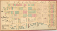
Annotated Copy of the "Ratzer Map," the Most Important Colonial Map of New York City -- Used By Anthony Bleeker To Settle An Early 19th Century Land Dispute
This is a rare Anthony Bleeker annotated copy of the Ratzer map, generally considered to be the most important eighteenth-century printed map of New York City. This example has been extensively annotated in 1810 to illustrate the properties of a number of the most important properties owned by major landowners on the east side of Midtown Manhattan, centered on the areas of Kip's Bay and Murray Hill.
The present map constitutes the northern half of Ratzer's 2-sheet map, which has been segmented and laid on linen, with annotations on the verso and the signature of Anthony Bleecker as Examiner in Chancery. Bleecker was one of the founding members of the New York Historical Society and a major figure in both real estate and literary circles in New York at the turn of end of the 18th and beginning of the 19th Centuries.
The Ratzer Map
Bernard Ratzer's map was the first large plan and by far the most accurate published plan of New York City on the eve of the American Revolution. The map is based on the surveys undertaken at the direction of Sir Henry Moore, who authorized mapping efforts in response to the Stamp Act Riots of 1765. He and other British leaders feared that the city might soon become a battleground -- a fear they no doubt carried over from the barely concluded French and Indian War. Needing a more detailed accounting of New York's layout, the British authorities commissioned Ratzer to survey and construct a map the city, which was drawn in 1766.
Ratzer's initial surveying produced his "Ratzen plan" (1769), which focused exclusively on lower Manhattan and gained its monicker from a misspelling in the title. The Ratzen plan was a great improvement on maps that had preceded it. In 1767, Ratzer would expand the scope of his surveying to cover the areas surrounding the city. The result was his remarkable map of New York City and its environs, first issued in 1770. This larger map is typically called the "Ratzer map." Cohen & Augustyn state that the Ratzer Map is perhaps the finest for an American city produced in the eighteenth century. The "geographical precision combined with highly artistic engraving was unsurpassed in the urban cartography of its day."
Lieutenant Bernard Ratzer (fl. 1756-1777) was a British cartographer Army officer who spent his time in America working as a surveyor and draftsman. He was, in particular, assigned to survey America's eastern coastline during the French and Indian War and later into the early stages of the American Revolution. He worked alongside his well-known contemporaries Claude J. Sauthier, Samuel Holland, and Thomas Jefferys.
Place Names Highlighted on The Map
The map identifies several early place names in color and identifies other early landowner names. These include:
- Rose Hill (highlighted in orange)
Rose Hill lies between Murray Hill to the north and Gramercy Park to the south. Its boundaries extend from 23rd Street to the south, 32nd Street to the north, Madison Avenue to the west, and Third Avenue to the east. The neighborhood, often associated with NoMad today, owes its name and early development to the prominent Watts family in the 18th and 19th centuries.
The name "Rose Hill" is derived from the estate owned by Robert Watts in the Bronx. In 1775, Robert's brother John Watts married Jane DeLancey, who lived on an adjacent property. The Manhattan neighborhood of Rose Hill was originally part of a 130-acre farm acquired by John Watts from James DeLancey in November 1747. The farm stretched along the East River between what would become 21st and 30th Streets, and between Fourth Avenue and the river. John Watts named the farm in honor of his father's estate near Edinburgh, Scotland.
John Watts, a Loyalist, left for Britain in 1775, leaving his Manhattan properties in the hands of his son, John Watts Jr. The main house at Rose Hill burned down in 1779 during the British occupation, but by the 1780s, the property included various buildings, orchards, and gardens. Parts of the farm were sold off in the 1780s; for instance, Nicholas Cruger bought a lot at the northern edge of the property in 1786.
In 1790, the Rose Hill Farm, with its elegant dwelling house, commodious farm buildings, and extensive orchards, was advertised for sale in the New-York Daily Advertiser, with the following description:
A Farm for Sale. That very elegant and pleasantly situated FARM, Rose Hill, lying on the banks of and adjoining the east river, three miles from this city, containing 92 acres of valuable land, in the highest cultivation, chiefly in mowing ground, the whole well inclosed, principally with stone fences of a superior construction, bounding on the public road 1175 feet; a pleasant avenue through the orchard in front of the house, also a good road that comes out into the bowery land, next to the honorable James Duane’s; on the premises there is an elegant dwelling house of 50 by 37 feet; a commodious farm house of 50 by 20 feet; an excellent barn with carriage houses and stable, 20 by 40 feet, a hovel with a large hay loft over the whole 96 by 15 feet, corn crib, fowl house &c. all the buildings are new and well finished in the most commodious manner, a fine bearing orchard of 260 engrafted apple trees of the most approved sorts, and a great variety of other kinds of the best English and American fruits, a thriving nursery of upwards of 9000 young fruit trees, numbers of which are inoculated and engrafted; an elegant garden, with the finest collection of flowers, flowering shrubs, strawberry, asparagus beds, etc. ten acres in wheat and rye.
Revolutionary War General Horatio Gates acquired part of the property and established his country seat there. He died at his estate in 1806, and the property later became a boarding house.
By the early 19th century, Rose Hill Farm was being subdivided and sold off. The Commissioners' Plan of 1811, which laid out Manhattan's street grid, further facilitated this development. By 1831, just southwest of Rose Hill, Gramercy Park was laid out, marking another phase of urban development in the area.
- Kip's Farm / Kip's Bay (highlighted in blue)
Kip's Bay, located on the east side of Manhattan, is a neighborhood bounded by 34th Street to the north, the East River to the east, 23rd Street to the south, and Third Avenue to the west. Kip's Bay derives its name from Jacobus Hendrickson Kip, a Dutch settler whose farm was established in the area during the 17th century. Kip's farm, which ran north of what is now 30th Street along the East River, was an expansive tract of land where he built a large brick and stone house near the modern intersection of Second Avenue and East 35th Street. This house, constructed in 1655, stood for nearly two centuries until its demolition in 1851. It was the last remaining farmhouse from the New Amsterdam era in Manhattan, and it was famous for its orchard.
Kip's Bay was also significant during the American Revolutionary War. On September 15, 1776, it was the site of the Landing at Kip's Bay. About 4,000 British troops under General William Howe landed at Kip's Bay, overwhelming approximately 500 American militiamen commanded by Colonel William Douglas. The American forces quickly retreated, allowing the British to occupy New York City. This event forced General Washington to retreat further north to the Harlem River.
The landscape of Kip's Bay changed considerably following the Revolutionary War. By the late 18th century, the original bay had been filled in, and the area began to develop. The Federal-style villa south of the Kip's Bay Farm, built by Henry A. Coster, marked the transformation of the area from rural farmland to more developed residential properties.
- Bridgen's Farm (highlighted in red)
This would be the farm of Thomas Bridgen Atwood. His property extended from just north of present-day East 38th Street to present-day East 41 st Street along the western side of the Eastern Post Road. To the east was the colonial-era farm of Jacobus Kip, which extended from the East River to the Eastern Post Road between East 28th Street and East 39th Street.
A portion of Bridgen's farm was lot to the Murray family through foreclosure in the early 1800s.
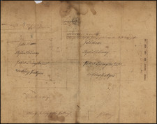
Text on Verso
In Chancery William Rogers and Ann Rogers his Wife & others vrs. Bertram P. Cruger and others
I certify that on the Twentieth day of July, one thousand eight hundred and ten, Cross? interrogatories were filed in my office on the part of the Defendants in this suit, to be administered to witnesses to be examined on the part of the Complainants, and that the within is the original map referred to in the said Interrogatories and deposed unto by Francis B. Winthrop, James A. Stewart, John R Murray, Elbert Kip, Henry Brevoort, Henry Cruger, Theodorus Bailey, Silvanus Miller, and David Hosack. Witness by me examined on the said Cross Interrogatories —
A. Bleecker
Examiner in Chancery
Anthony Bleeker
Anthony Bleecker (1770–1827) was an American lawyer, editor, and writer notable for his contributions to the early literary scene of New York. Born into a prominent New York family, Bleecker received a robust education, which laid the foundation for his diverse career. After graduating from Columbia College in 1791, he pursued a career in law, practicing for several years before shifting his focus to literary and editorial endeavors.
For many years, he served as Examiner-in-Chancery, a role that positioned him at the center of numerous property law cases. His expertise in examining the details of these disputes made him a sought-after authority in land ownership and transactions, contributing significantly to the development and organization of New York City's real estate market. His legal acumen in these matters not only advanced his professional reputation but also played a crucial role in shaping the legal framework for property rights and development in the city.
Bleecker was also a key figure in the establishment of the literary culture in New York during the early 19th century. He contributed to various periodicals and was a founding member of the New York Historical Society, an institution dedicated to the preservation and promotion of American history. His involvement with the Society underscored his commitment to the cultural and intellectual development of the city.
In addition to his legal and editorial work, Bleecker was known for his poetry and essays, which were published in several contemporary magazines and journals. His writings often reflected the social and political milieu of his time, providing insight into the early American republic's evolving identity. Bleecker's literary style was marked by a blend of classical influences and contemporary themes, earning him a respected place among his peers.
Bleecker's contributions extended beyond his own writings; he was a mentor and supporter of other emerging writers, fostering a collaborative literary community in New York. His efforts helped to establish the city as a burgeoning center of American literature and intellectual discourse.
Anthony Bleecker passed away in 1827, leaving behind a legacy of literary and cultural contributions that continued to influence the New York literary scene long after his death. His work as a writer, editor, Examiner-in-Chancery dealing with real estate disputes, and cultural advocate remains a testament to his enduring impact on American literature and the intellectual life of New York City.
Other Names on the Verso
- Francis B. Winthrop -- The Turtle Bay Farm
Francis Bayard Winthrop was, at the time, owner of the Turtle Bay Farm immediately north of Kip's Farm on the map. Winthrop was a prominent New York City landowner and member of the influential Winthrop family, descendants of John Winthrop, the first governor of the Massachusetts Bay Colony. Born in 1767, Francis B. Winthrop inherited considerable wealth and property, which he managed and expanded throughout his life. He was actively involved in various civic and philanthropic activities, contributing to the social and economic development of New York City in the early 19th century. Winthrop's land holdings and investments significantly influenced the urban landscape, particularly in areas such as Greenwich Village, where he owned substantial tracts of land. The New York Public Library holds the Francis B. Winthrop collection of New York City and Cheesecock Patent land papers. In 1812, Winthrop made a gift of nearly 300 books to the New York Society Library.
- James A. Stewart
James A. Stewart, a prominent wine merchant in early 19th-century New York City, advertised offerings like "Old Genuine Madeira Wine," "Rich Lisbon Wine," and "Old Red Port" in The American Citizen in 1805. By 1806, he sought to sell or lease part of his farm near Federal Hall. His real estate ambitions grew, and in 1809, he advertised his "country seat" with two acres of pasture and lots on "Stewart Street," a tree-lined road he described as “the handsomest road in the city.”
In 1810, Stewart requested the Common Council to accept Stewart Street as a public road, but the street commissioner opposed it, citing conflicts with the new grid plan adopted in 1811. As a result, Stewart Street was never fully realized, and most of his land was reconfigured into conventional lots. However, the Bijou Building at 1239 Broadway, built in 1915, stands as a remnant of his vision, retaining the unique angled form from his original plan.
- John R. Murray (1737–1808) - Murray Hill
John R. Murray was a prominent New York merchant and landowner in the late 18th and early 19th centuries. Born in 1737, Murray was a member of the influential Murray family, known for their significant contributions to commerce and real estate in New York City. He was actively involved in various business ventures and owned extensive land holdings in Manhattan. Murray Hill, a neighborhood in New York City, is named after his family. His contributions to the city's development were substantial, particularly in the areas of trade and urban planning.
- Elbert Kip (1763–1838) - Kip Farm
Elbert Kip was a notable landowner and businessman in New York City during the late 18th and early 19th centuries. Born in 1763, Kip was a member of the prominent Kip family, which had settled in New Amsterdam (now New York City) in the 17th century. He inherited and managed substantial properties in Manhattan, contributing to the city's real estate development. Kip's involvement in local affairs and his management of family estates helped shape the urban landscape of early New York City.
- Henry Brevoort (1782–1848)
Henry Brevoort (1747-1841) was a successful farmer whose lands lay just outside the early city limits of New York. His estate consisted of 86 acres between 9th Street and 18th Street, bounded by Fifth Avenue on the west and the Bowery on the east, thus part of today's West Village. This extensive landholding made Brevoort a prominent figure in the development and shaping of early New York City.
Brevoort's influence was particularly notable in urban planning decisions of the time. The opening of Broadway up to 23rd Street forced New York City Street commissioners to create a dog-leg bend at 10th Street, a rare deviation from the grid plan, as Brevoort was determined to prevent the disruption of his estate. This insistence on maintaining the integrity of his land exemplifies Brevoort's significant impact on the city's layout.
In the 1830s and 1840s, Henry Brevoort and his son, Henry Jr., successfully prevented the opening of 11th Street between Broadway and the Bowery. Their efforts were aimed at preserving the old family farmhouse, demonstrating the Brevoort family's commitment to maintaining their historic estate amidst the city's rapid expansion. This resistance to urban development highlights the Brevoorts' role in shaping the physical and cultural landscape of New York City.
- Henry Cruger (1739–1827)
Henry Cruger Jr. was an American and British merchant at the time of the American Revolution, notable for his rare distinction of having been elected to both the Parliament of Great Britain and the New York State Senate.
Born into a wealthy merchant family in New York, his father (Henry Sr.) was a prominent member of the New York General Assembly and the governor's council, his eldest brother, John Harris Cruger, succeeded their father on the governor's council and was a Loyalist during the American Revolution. His other brothers settled in the West Indies, and his sister, Mary Cruger, married Jacob Walton, also a representative in the General Assembly for New York.
Henry studied at King's College (now Columbia University) in New York City, but he moved to Bristol, England, in 1757 before graduating. Upon relocating to Bristol, Henry Cruger joined a family mercantile house and achieved significant wealth. Cruger was elected to the Bristol Common Council in 1765, serving until 1790, and held the position of sheriff from 1766 to 1767. He became a warden of the Society of Merchant Venturers in 1768 and its Master in 1781. Cruger was elected as Member of Parliament for Bristol as a radical Whig in the 1774 general election, at a time when British policy towards the American colonies was a significant issue. In his maiden speech before Parliament, Cruger criticized British policies for exacerbating the rift with the colonies. He advocated for the rights of British sympathizers in New York, supported the repeal of the Declaratory Act, and eventually favored American independence by 1780. Cruger became mayor of Bristol in 1781. He was re-elected to Parliament in the 1784 general election as a supporter of William Pitt the Younger, continually urging reconciliation with America. In 1789, he unsuccessfully sought a consular appointment in the United States from Pitt.
Cruger returned to New York in 1790 after a 33-year absence. He was elected as a Federalist to the New York State Senate in 1792, where he served a single four-year term. During his tenure, he continued to advocate for conciliation with Great Britain, maintaining his lifelong commitment to bridging the divide between his two homelands.
- Theodorus Bailey (1758–1828)
Theodorus Bailey was a prominent lawyer, politician, and landowner in New York. Born in 1758, Bailey served as a U.S. Representative and Senator from New York, playing a crucial role in the early political landscape of the United States. In addition to his political career, Bailey was a significant landowner in New York City, where his real estate investments and legal expertise contributed to the city's development. His legal and political activities, combined with his land management, made him a key figure in the early 19th century.
- Silvanus Miller (1770–1861)
Silvanus Miller was a distinguished lawyer and landowner in New York City during the early 19th century. Born in 1770, Miller served as the Surrogate of New York County, a position in which he managed the probate of wills and estates. His extensive knowledge of law and property rights made him a prominent figure in real estate circles. Miller's land holdings and legal work significantly influenced the development of New York City's property laws and urban growth.
- David Hosack (1769–1835) - Elgin Botanic Garden
David Hosack was a renowned physician, botanist, and landowner in New York City. Born in 1769, Hosack is best known for his role as the attending physician at the duel between Alexander Hamilton and Aaron Burr. He founded the Elgin Botanic Garden, the first public botanical garden in the United States, on land he owned in what is now Rockefeller Center. Established in 1801, the garden was located between present-day 47th and 51st Streets and Fifth and Sixth Avenues in Midtown Manhattan, the garden covered 19¾ acres. Hosack's vision was to cultivate native and medicinal plants, and by 1805, it housed 1,500 species. Financial strains forced Hosack to sell the garden to the State of New York in 1810.
In 1814, the property was transferred to Columbia College, which neglected its upkeep. By 1823, the garden had fallen into disrepair, and its remaining plants were moved to the Bloomingdale Asylum. The site, later developed for residential use, deteriorated by the 1920s. In 1928, Columbia leased the land to John D. Rockefeller Jr., leading to the construction of Rockefeller Center, which now occupies the original garden site.
Rarity
The Ratzer map is rare on the market.
A segmented example of the map in full original color was sold by Christies in 2022 for $625,000.
This is the first example we have ever seen on the market which was used for an official proceeding before the Court of Chancery in New York City.
![Rand, McNally & Co's Map of the Main Portion of Brooklyn [on verso] Map of the Southern Portion of New York City](https://storage.googleapis.com/raremaps/img/small/86750.jpg)
![[ Brooklyn ] Fort Hamilton, New York Bay.](https://storage.googleapis.com/raremaps/img/small/103703.jpg)