


|
||

|

|
|

|
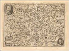
Rare early regional map of France. One of the more interesting features of the map is the date (1625) and the reference to the collaborative work of Henricus Hondius (who published the map in Amsterdam) and Melchior Tavernier (who sold the map in Paris). The map was bound into a rare 1631 edition of the Theatrum Universae Galliae, which Koemann referred to as an experimental atlas published by Henricus Hondius and Jan Jansson, of which only 3 copies are known to exist. A different map of Sarlat appears in later atlases by Hondius. This is also the first reference we have ever seen to the Tavernier/Hondius collaboration. A nice old color example.
Henricus Hondius (1597-1651) was a Dutch engraver and mapmaker, a member of a prominent cartographic family. His father, Jodocus Hondius, was also an engraver and geographer. While working with his father, Henricus was instrumental in the expansion and republishing of Mercator’s atlas, first published in 1595 and republished by Hondius in 1606.
Upon his father’s death in 1612, Henricus and his brother, Jodocus the Younger, took over the business. He set up his own shop in 1621, where he continued to release new editions of the Mercator atlas. Later, he partnered with his brother-in-law, Jan Janssonius, in continuing to expand and publish Mercator’s atlas, which would become known as the Mercator-Hondius-Janssonius atlas. Born and based in Amsterdam, he died there in 1651.
![(First World War - Seriocomic) Европа въ 1915 г. [Europe in 1915]](https://storage.googleapis.com/raremaps/img/small/98679.jpg)
![[Grand View of Paris] Lutetiae, vulgo, Paris, Urbis Galliarum Primariæ, Non Europæ Solius, Sed Orbis Totius Celeberrimæ Prospectus](https://storage.googleapis.com/raremaps/img/small/77258.jpg)
![Regionis Biturigum Exactiss: Descriptio Per D. Ioannem Calamaeum [with] Limaniae Topographia Gabriele Symeoneo Auct.](https://storage.googleapis.com/raremaps/img/small/61579.jpg)