|
||

|

|
|

|
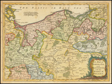
This detailed map of the Upper Saxony Circle, published around 1700, presents a comprehensive representation of the Duchy and Electorate of Saxony, the Margraviate of Meissen, the Landgraviate of Thuringia, the Principality of Anhalt, and the regions of Brandenburg. The map meticulously delineates the political and geographical landscape of the region at the dawn of the 18th century, highlighting its significant towns, rivers, and topographical features.
The map prominently features major towns such as Dresden, Leipzig, and Wittenberg. Dresden, the capital of the Electorate of Saxony, was a cultural and political hub, celebrated for its splendid Baroque architecture and vibrant court life. Leipzig, a key commercial center, was famous for its trade fairs and its role in the intellectual and cultural movements of the time. Wittenberg, historically significant for its association with Martin Luther and the Protestant Reformation, remained an important religious and educational center.
Rivers like the Elbe, Saale, and Mulde are meticulously depicted, reflecting their importance in the region's commerce and transportation. The Elbe River, flowing through Dresden and providing a vital waterway for trade, played a significant role in the economic prosperity of the Saxon territories. The Saale and Mulde rivers also contributed to the region's agricultural and economic activities, supporting the towns and settlements along their banks.
In the early 18th century, the Upper Saxony Circle was a pivotal region within the Holy Roman Empire, encompassing several influential territories. The Electorate of Saxony, ruled by the Elector Frederick Augustus I (Augustus the Strong), was a dominant power, renowned for its cultural and political influence. Augustus, who also became King of Poland in 1697, played a crucial role in the region's politics and arts, fostering a period of significant architectural and artistic development known as the Saxon Baroque.
Gerard Valk, or Gerrit Leendertsz Valck (1652-1726) together with his son Leonard, were the only significant publishers of globes in the Netherlands in the eighteenth century, enjoying an almost total monopoly in the first half of the 1700's. Initially an engraver and art dealer, and having worked for map-sellers Christopher Browne and David Loggan in London between 1672 and 1679, Valk established the firm in Amsterdam in 1687. Initially, they published maps and atlases, but in 1700 the company moved the shop to the building previously occupied by map and globe-maker Jodocus Hondius. In 1701, he applied for a charter for making globes and the "Planetolabium", designed by Lotharius Zumbach de Coesfelt (1661-1727), an astronomy lecturer at Leiden University. The Valks produced several editions of 3, 6, 9, 12, 15, 18 and 24-inch diameter terrestrial and celestial globes. The cartography, as stated on the cartouche, is based closely on the celestial atlas Uranographia, published in 1687 by the celebrated Polish astronomer Johannes Hevelius (1611-1687).
Around 1711, when he became a member of the bookseller's guild, Leonard Valk (1675-1746) came into partnership and his name started to appear alongside that of his father on the cartouches of the globes, although the earliest of these, both terrestrial and celestial, still bear the date 1700. Leonard naturally took over the business on his father's death in 1726, and following his own death in 1746 the firm was run by Maria Valk, cousin, and wife to Gerard. By then its days of glory had passed. Leonard Valk died in relative poverty: his wife had to take in the washing of their aunt to make ends meet. The late eighteenth century saw a number of successful reissues by publisher Cornelis Covens (1764-1825), who ran the famous cartographical publishing house of Covens & Mortier (1721-1866) in Amsterdam. This firm was the biggest Dutch one for publishing maps in the 18th century. It was located on the Vijgendam (Fig Dam), the southern part of what is now Dam Square, the central hub of the city. They didn't move out of their building, but they did change addresses. At first in 1795 the whole Dam was rebaptized into Revolution Square, then it got the name Napoleon Square, till in 1813 after Napoleon's fall Covens & Mortier were back again at the Vijgendam.
![[ Brandenburg & Pomerania ] Tabula Electoratus Brandenburgici, Meckelenburgi et Maximae Partis Pomeraniae . . . 1630](https://storage.googleapis.com/raremaps/img/small/99232.jpg)
![[ Southwestern Prussia ] Des Konigreichs Preussen westsudlicher Theil mit der freyen Stadt Thorn Nro. 53.](https://storage.googleapis.com/raremaps/img/small/101864.jpg)