|
||

|

|
|

|
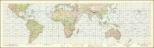
This double hemisphere map of the world provides an exceptional depiction of the contemporary understanding of global geography in the latter part of the 18th century.
The map illustrates notable geographic developments of the time, such as the separation of Neu Holand (Australia) from New Guinea, although Van Diemen's Land (modern Tasmania) is still erroneously depicted as being connected to the Australian mainland. The representation of Neu Seeland (New Zealand) reflects the discoveries made by Captain James Cook, including the accurate delineation of Cook's Strait.
The map's portrayal of the northwest coast of North America is particularly interesting, as it updates previous misconceptions by rejecting the myth of the Sea of the West. However, it lacks the detailed information later provided by the expeditions of George Vancouver and remains reliant on the Russian discoveries of the 1740s, which suggest the possibility of an open-ended Northwest Passage. This depiction highlights the evolving understanding of the region and the gradual correction of earlier geographic errors.
A notable feature of this map is the inclusion of a curious landmass labeled Sandwich Land, located to the south of South America. Additionally, the map references Captain Cook's southern voyages of 1774, emphasizing the significance of his contributions to the exploration and mapping of the southern hemisphere.
Overall, this map serves as an excellent example of 18th-century cartography, showcasing the period's advances in geographic knowledge while also reflecting the limitations and uncertainties of the time.
![[ The Lost Paulus Ageminius Casket Map ]](https://storage.googleapis.com/raremaps/img/small/97534.jpg)
![Ленин – вождь международного пролетариата [Lenin – Leader of the International Proletariat]](https://storage.googleapis.com/raremaps/img/small/93242.jpg)
![Newsmap. Monday, July 27, 1942 [on verso:] Tanks of the British Army](https://storage.googleapis.com/raremaps/img/small/93349.jpg)