|
||

|

|
|

|
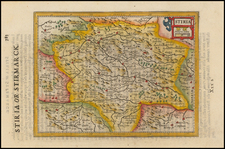
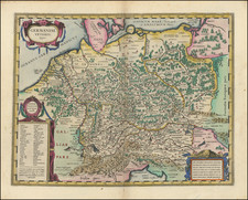
This 18th-century map, titled Archiducatus Austriae Inferioris In Omnaes Suas Quadrantes Ditionis Divisi Nova et Exacta Tabula, presents a detailed depiction of Lower Austria, meticulously divided into its constituent regions. The map’s detailed division of Lower Austria into quadrants reflects the administrative precision and territorial organization that were characteristic of Habsburg rule.
The map prominently features Vienna (Wien), the capital of Austria and a significant cultural, political, and economic center in the 18th century. Other notable cities include Wiener Neustadt, known for its military academy and strategic importance, and Krems, an essential wine-producing town situated along the Danube River.
The map intricately charts the course of the Danube River, the longest river in Western Europe, which flows through the heart of Lower Austria, providing a vital trade route that connects various regions. The Danube’s tributaries, including the Traisen and the Ybbs, are also carefully depicted, highlighting their importance in the region's geography and economy.
The map illustrates the mountainous terrain to the west and south, including the Wienerwald (Vienna Woods) and the foothills of the Alps, which form a natural barrier and significantly influence the climate and agricultural patterns of Lower Austria. These mountainous areas were crucial for defense and provided timber and other resources.
Johann Baptist Homann (1663-1724) was a mapmaker who founded the famous Homann Heirs publishing company. He lived his entire life in Bavaria, particularly in Nuremberg. Initially, Johann trained to become a priest before converting to Protestantism and working as a notary.
In 1702, Johann founded a publishing house that specialized in engravings. The firm flourished, becoming the leading map publisher in Germany and an important entity in the European map market. In 1715, Johann was named Imperial Geographer to the Holy Roman Empire by Charles VI and made a member of the Prussian Academy of Sciences. Most importantly for his business, his reputation and contacts gained him imperial printing privileges which protected his publications and recommended him to customers. Johann is best known for this Grosser Atlas ueber die ganze Welt, or the Grand Atlas of the World, published in 1716.
After Johann died in 1724, the business passed to his son, Christoph (1703-1730). Upon Christoph’s early death, the company passed to subsequent heirs, with the name of the company changing to Homann Erben, or Homann Heirs. The firm continued in business until 1848.
![[Vienna] Prospect und Grund Riss der Kayserl Residenz-Stadt Wien . . .](https://storage.googleapis.com/raremaps/img/small/81235.jpg)