
The item illustrated and described below is sold, but we
have another example in stock. To view the example which
is currently being offered for sale, click the
"View Details" button below.
1853 Thomas, Cowperthwait & Co.
$ 165.00


|
||

|

|
|

|
Stock# 10453
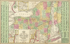
Description
Highly detailed map of New York, hand colored by counties and showing towns, roads, railroads, rivers, canals, steamship routes, etc. Large population table for the counties and townships. Large insets for New York City, Albany, Niagara Falls, Rochester and the Hudson River. A colorful and information filled map, one of the most highly sought after mid-19th Century maps of New York State to appear in a commercial atlas. A nice example of this marvelous map.