|
||

|

|
|

|
Stock# 104515
Description
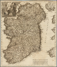
Engraved map of Ireland in two sheets, each really a separate map of the north and south of Ireland respectively. The map shows rivers, roads, towns, castles, forests, lakes and a host of other details.
From Franz Johann Joseph von Reilly atlas Schauplatz der fünf Theile der Welt / nach und zu Anton Friedrich Büschings grosser Erdbeschreibung in drey Theilen
Von Reilley & Schaembl led a revival of map-making in Vienna in the late 18th century, which included this and several other sought-after works.
Condition Description
Engraving on two sheets of 18th-century paper, unjoined. Original wash hand-color. Minor centerfold and marginal toning.
![[ Ireland ] Hiberniae Regnum tam in praecipuas Ultoniae, Connaciae, Lageniae, et Momoniae. . .](https://storage.googleapis.com/raremaps/img/small/78023.jpg)
![[Youghal] The Towne of Youghall](https://storage.googleapis.com/raremaps/img/small/83704.jpg)
![[Hungarian Map of Great Britain] Nagy Britannia](https://storage.googleapis.com/raremaps/img/small/85219.jpg)