|
||

|

|
|

|
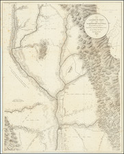
Mapping a Mining Claim Which Ultimately Successfully Reverted to A Native American Claimant
Interesting early mining plat map, identifying the claims of Ethel Mining and Last Chance, along with the Homestead of J.W. Donohue at the confluence of the Trinity River and South Fork of the Trinity River.
The area shown is now the location of Hyampom and Merlo Vineyards. The map was created in about 1915 when the land was originally patented to Peter P. Hammer and Jacob Kahlke under a mineral entry. At the time the patent was issued, an application by Indian Pete, a member of the Hoopa Valley Tribe, for the same land was pending but overlooked due to an administrative error. Indian Pete had occupied the land within the Trinity National Forest along with his wife, Julia Pete.
The United States reacquired the title to the land in 1943 via a bargain and sale deed executed by the successors of Hammer and Kahlke. This was in settlement of litigation initiated by the United States to exclude the land claimed by Indian Pete from the original patent. The title was then conveyed to the United States in trust for David Peters, the only surviving heir of Indian Pete.
David Peters applied for and received an order in 1953 intended to remove restrictions and enable the alienation of the land. However, for David Peters to acquire a good legal title or fee patent, it was determined necessary to obtain an act of Congress authorizing and directing the Secretary of the Interior to issue a fee patent to David Peters, his heirs, or assigns.
![[Early Landsat Photocomposite of California]](https://storage.googleapis.com/raremaps/img/small/90468.jpg)
![[Orange County Ranchos -- Signed by Orange County Surveyor]](https://storage.googleapis.com/raremaps/img/small/92333.jpg)