


|
||

|

|
|

|
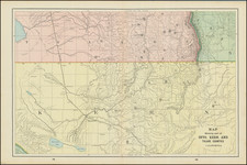
Rare topographical map extending from Lake Tahoe to Mud Flat, Horse Lake and the area above Pyramid Lake.
Shows towns, roads, mountains, rivers, lakes, hydrographical details, etc.
The map was generated during the Wheeler Survey. The Wheeler Survey was a survey of a portion of the United States lying west of the 100th meridian. It comprised multiple expeditions, and was supervised by First Lieutenant (later Captain) George Montague Wheeler. The survey team included Lieutenant (later Brigadier General) Montgomery M. Macomb.
Wheeler led early expeditions from 1869 to 1871, in the west, and in 1872 the US Congress authorized an ambitious plan to map the portion of the United States west of the 100th meridian at a scale of 8 miles to the inch. This plan necessitated what became known as the Wheeler Survey. The survey's main goal was to make topographic maps of the southwestern United States.
In addition, Wheeler's survey was undertaken to ascertain everything related to the physical features of the region; discover the numbers, habits, and disposition of Indians in the section; select sites for future military installations; determine facilities available for making rail or common roads; and note mineral resources, climate, geology, vegetation, water sources, and agricultural potential.
The Wheeler Survey lasted until 1879, when the survey, along with the King and Powell Surveys, were terminated and their work was reorganized as the United States Geological Survey.
Provenance
Colonel George Ruhlen (1884-1971), noted Southern California historical geographer.
![[ Ventura ] Automobile Road Map of Ventura County California . . .](https://storage.googleapis.com/raremaps/img/small/99431.jpg)
![[Southern California] Map of Automobile Roads Banning California](https://storage.googleapis.com/raremaps/img/small/45357.jpg)
![[Report and] Map of an Exploring Expedition to The Rocky Mountains in the Years 1842 and to Oregon & North California in the Years 1843-44 By Brevet Capt. J. C. Fremont of the Corps of Topographical Engineers . . .](https://storage.googleapis.com/raremaps/img/small/88488.jpg)