|
||

|

|
|

|
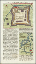
Rare French & Indian War Plan of Fort Ticonderoga -- The Battle of Fort Carillon
This finely executed plan of Fort Ticonderoga (then known as Fort Carillon) and its surroundings is the finest extent record of this important battle during the French & Indian War (Seven Years War).
Mante's plan details the layout of the fortress, its strategic position commanding the river between Lakes George and Champlain, and the troop positions during General James Abercromby's catastrophic frontal assault on French fortifications. Under the command of General Louis-Joseph de Montcalm, the French forces were significantly outnumbered, yet the difficult terrain of Ticonderoga allowed only one avenue of attack for the British ground troops. Well-entrenched and protected by a dense abatis constructed by the French to defend the fort, the French repelled multiple advances, inflicting nearly 2,000 casualties on the British regulars and American militia. Along with the defeat of General Braddock’s force on the Monongahela in 1755, this battle was one of the most notable British military failures of the French & Indian War.
Fort Carillon, later known as Fort Ticonderoga, was a strategic stronghold built by the French between 1755 and 1757 during the French & Indian War. Situated on a narrow strip of land at the southern end of Lake Champlain, the fort was designed to control the crucial portage between Lake Champlain and Lake George. Its location was of paramount importance for controlling access to the interior of North America, making it a focal point of military operations during the war. This fortification was originally constructed under the direction of Michel Chartier de Lotbinière, Marquis de Lotbinière.
The Battle of Fort Carillon, fought on July 8, 1758, was a significant engagement in the French & Indian War. British forces, numbering approximately 15,000 men and led by General James Abercromby, launched a direct assault on the fort, which was defended by a much smaller French force of around 3,600 troops under the command of General Louis-Joseph de Montcalm. Despite their numerical superiority, the British faced formidable natural and man-made defenses. The French had fortified their position with extensive earthworks and a dense abatis—a barrier of felled trees with sharpened branches pointing outward, making any approach exceedingly difficult.
The British plan hinged on a frontal assault, a tactic that proved disastrous. Abercromby underestimated the strength of the French defenses and overestimated the capabilities of his own troops. The assault began with a heavy artillery bombardment led by Major General John Forbes, but the terrain and fortifications mitigated its effectiveness. As British troops advanced, they encountered fierce resistance from the French, who were well-prepared and strategically positioned. Wave after wave of British soldiers were cut down by musket fire and artillery as they struggled to navigate the abatis and reach the French lines.
The battle was marked by intense combat and heavy casualties. British and American colonial forces suffered nearly 2,000 casualties, while French losses were significantly lower, estimated at around 400. The failure of the British assault was due in part to poor leadership and planning by Abercromby, who failed to adapt to the challenging terrain and the strength of the French defenses. The British retreat was chaotic, and the defeat at Fort Carillon was a significant blow to British morale and military prestige.
In the aftermath of the battle, General Abercromby was replaced by General Jeffrey Amherst, who would later capture Fort Carillon (Ticonderoga) on July 26, 1759. The French victory at Fort Carillon bolstered their control over the region and delayed British advances into the interior of North America.
This plan of Fort Ticonderoga, with its detailed depiction of the fortress, troop positions, and surrounding terrain, serves as perhaps the best contemporary printed record of the battle. It provides insight into the strategic considerations and military engagements of the time, offering a glimpse into one of the most significant battles of the French and Indian War.
Rarity
This plan and Mante's The History of the Late War in North-America, and the Islands of the West Indies, are both very rare on the market, with Mante's work considered the best contemporary account of the French and Indian War, celebrated for its cartography and textual content, and one of the great rarities of colonial Americana.
This is the second example of the map we have offered for sale in the past 30+ years (1992-2024).

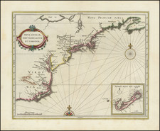
![[Carolinas, Virginia, the Chesapeake, Pennsylvania, New York]](https://storage.googleapis.com/raremaps/img/small/71479.jpg)