


|
||

|

|
|

|
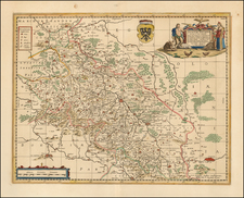
This splendidly detailed map from the 1740s, titled Moravia Marchionatus in Sex Circulos Divisus Juxta Recentissimas Dimensionem et Accuratissimas Observationes Aeri Incisus et Venum Expositus, represents the historical region of Moravia, then a margraviate within the Habsburg Monarchy.
The map is divided into six administrative districts, reflecting the territorial divisions of the time. It is adorned with an elaborate title cartouche and detailed city views, emphasizing the region's urban and cultural significance.
Moravia, lying in the modern-day Czech Republic, was a vital and prosperous region during the 17th and 18th centuries, known for its agricultural productivity, viticulture, and burgeoning industry. The map captures the region at a time when it was reestablishing stability and growth following the devastations of the Thirty Years' War. The depiction of major towns such as Brno (Brünn), Olomouc (Olmütz), and Znojmo (Znaim) highlights these as significant urban centers. These cities were crucial for their strategic locations, cultural heritage, and as hubs of trade and governance.
The map features detailed renderings of rivers like the Morava River, which was central to the region’s agriculture and commerce, serving as a vital waterway linking various parts of Moravia with the Danube and thereby to the broader European trade networks. This cartographic piece showcases the geography and hydrology of Moravia with precision, indicating the importance of these natural resources in the socioeconomic life of the region.
Additionally, the artistic embellishments within the map, such as the decorative border scenes depicting Brno, showcase the map’s dual function as both a practical and a ceremonial object. These urban landscapes serve to elevate the map’s aesthetic appeal and provide a visual connection to the physical landscape of Moravia.
Matthäus Seutter (1678-1757) was a prominent German mapmaker in the mid-eighteenth century. Initially apprenticed to a brewer, he trained as an engraver under Johann Baptist Homann in Nuremburg before setting up shop in his native Augsburg. In 1727 he was granted the title Imperial Geographer. His most famous work is Atlas Novus Sive Tabulae Geographicae, published in two volumes ca. 1730, although the majority of his maps are based on earlier work by other cartographers like the Homanns, Delisles, and de Fer.
Alternative spellings: Matthias Seutter, Mathaus Seutter, Matthaeus Seutter, Mattheus Seutter
![[Holy Roman Empire] A Newe Mape of Germany Newly Augmented by Iohn Speed Ano Dom: 1626](https://storage.googleapis.com/raremaps/img/small/67323.jpg)
![(Austria) Charte der Österreichischen Monarchie, nach den letzten Friedensschlüssen berichtigt. [Map of the Austrian Monarchy, corrected according to the latest peace treaties.]](https://storage.googleapis.com/raremaps/img/small/102892.jpg)