


|
||

|

|
|

|
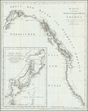
Mapping The Geology of Haida Gwaii -- The Queen Charlotte Islands
This detailed geological map provides a comprehensive geological survey of the Queen Charlotte Islands (now known as Haida Gwaii), based on the observations and surveys conducted by George M. Dawson in 1878.
The main map depicts the islands with intricate detailing of the geological formations, including various rock types and strata. The map uses different colors and patterns to represent these formations, as indicated in the legend at the bottom right. The legend specifies various geological units such as Miocene, Cretaceous formations, conglomerates, sands and ashes of likely Triassic volcanic origin, Triassic formations, intrusive granites, diorites, and locations of fossils older than the Cretaceous formation, along with occurrences of iron, lead, and copper.
The map also includes an inset showing the Skidegate Inlet area in greater detail. This inset, titled "Skidegate Inlet nach den Vermessungen von J. Richardson 1872 & G.M. Dawson 1878," is scaled at 1:350,000 and highlights the inlet's geological features with similar color-coded strata. It indicates various coal mines, geological features, and the names of notable locations within the inlet.
To the left of the main map, there are detailed illustrations of various ethnographic artifacts collected from the indigenous Haida people. These include:
- Stäbe eines Spieles (Game sticks)
- Hornlöffel (Horn spoon)
- Eiserner Angelhaken mit Schwimmer (Iron fishhook with float)
- Fischkeule (Fish club)
- Hölzerner Angelhaken (Wooden fishhook)
- Castanette aus Schneiben des Papageifuchers (Castanet made from parrotfish vertebrae)
- Rassel (Rattle)
These artifacts highlight the cultural and practical items used by the indigenous people of the region.
M. Dawson, referred to on the map, is George Mercer Dawson (1849-1901), a prominent Canadian geologist and surveyor. Dawson was known for his extensive geological surveys of western Canada, including British Columbia and the Yukon Territory.
George M. Dawson played a crucial role in mapping and exploring the geological features of the Canadian frontier. His work provided valuable insights into the natural resources and geological formations of the regions he surveyed. In 1878, Dawson conducted a significant geological survey of the Queen Charlotte Islands (Haida Gwaii), which is the basis for the map in question. His detailed observations and mappings contributed to the understanding of the geology and potential resource deposits in these areas.
Dawson's contributions to geology extended beyond his field surveys; he published numerous reports and papers that advanced the knowledge of Canadian geology. He was also instrumental in the early development of the Geological Survey of Canada, where he served as the director from 1895 until his death in 1901. His legacy in Canadian geology is remembered through various honors, including the naming of Dawson City in Yukon Territory and the Dawson Range in his honor.
August Heinrich Petermann (1822-1878) is a renowned German cartographer of the nineteenth century. Petermann studied cartography at the Geographical Art-School in Potsdam before traveling to Edinburgh to work with Dr. A. Keith Johnston on an English edition of Berghaus’ Physical Atlas. Two years later he moved to London, where he made maps and advised exploratory expeditions as they set off to explore the interior of Africa and the Arctic.
In 1854, Petermann returned to Germany to be Director of the Geographical Institute of Justus Perthes in Gotha. There, he was the editor of the Geographische Mittheilungen and Stieler’s Handatlas. The Royal Geographical Society of London awarded him their Gold Medal in 1860. He continued his interest in exploration in Germany, fundraising for the German Exploring Expeditions of 1868 and 1869-70, which sought an open Arctic sea. Tragically, he committed suicide in 1878.
![[ Indigenous Tribes of Vancouver Island etc. ] Die Indianerstämme von Vancouver I. und an der Küste von Britisch-Columbia. Nach eigenen Forschungen gezeichnet von Dr. Franz Boas.](https://storage.googleapis.com/raremaps/img/small/104438.jpg)
![[San Francisco to British Columbia] Carta particolare dello stretto di Iezo fra l'America e I'Isola Iezo . . . D'America Carta XXXIII](https://storage.googleapis.com/raremaps/img/small/67788.jpg)
