|
||

|

|
|

|
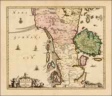
Scarce map of the Duchy of Schleswig in the latter part of the 18th Century.
The map depicts the Duchy of Schleswig, a historical region situated in the southern part of the Jutland Peninsula. The map covers the area extending from Jutland in the north to Holstein in the south and includes the islands of Funen (Fyn) and Als, as well as the surrounding coastal areas.
In the 18th century, Schleswig was a region of significant political and cultural importance, marked by its unique status and complex relationship with Denmark and the Holy Roman Empire. The Duchy of Schleswig was historically a fiefdom of the Kingdom of Denmark, and its governance and allegiances were often intertwined with those of the neighboring Duchy of Holstein, which was a part of the Holy Roman Empire.
During this period, Schleswig and Holstein were ruled by the Danish king in a personal union, although the territories had distinct legal and administrative systems. The region's population was a mix of Danish and German speakers, and the cultural influences of both Denmark and the German states were evident in various aspects of daily life, including language, education, and trade.
From Von Reilly's exceedingly scarce Grosser Deutscher Atlas. Von Reilley & Schaembl led a revival of map making in Vienna in the late 18th Century which included this and several other sought after works.
![[Jutland and Fyn Island]](https://storage.googleapis.com/raremaps/img/small/39278.jpg)
![[ Mecklenburg-Vorpommern, Rugen, Bornholm, Lubeck, Sonnderborg,Svendborg, Zealand ] Beschrijvinghe vant zuijder deel vande Belt, en hoemen de Custen van Mekeleborch Pomeren, met de Lande daer tegen over tusschen emeren en Bornholm geleghe besijlen en alle Reve en Sanden daer ontrent Shouwen Sal.](https://storage.googleapis.com/raremaps/img/small/61988.jpg)