|
||

|

|
|

|
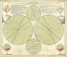
A very decorative double hemisphere celestial chart, centred on the North and South Poles, with smaller circular diagrams illustrating the theories of Tycho, Ptolemy, Landsbergen and Copernicus, two armillary spheres, 2 terrestrial globes, showing the inter-relation of the moon and tides, the illumination of the moon by the sun and the path of the earth around the sun. Warner; The Sky Explored, p.164 No.1. The present example has been trimmed to the neat line, with the corners cut, and laid on old paper, which was bound into what was likely a composite atlas. There are 5 small holes on the edges, perhaps from an early mounting on the wall, prior to rebinding into a composite atlas. A good example in old color. Normally a $2000.00 map.
Tobias Conrad Lotter (1717-1777) is one of the best-known German mapmakers of the eighteenth century. He engraved many of the maps published by Matthaus Seutter, to whose daughter Lotter was married. He took over Seutter’s business in 1756. Lotter’s son, M. A. Lotter, succeeded his father in the business.
![Sphere Droite [and] Sphere Parallele](https://storage.googleapis.com/raremaps/img/small/6208.jpg)
![[ Twin Hemispheric Maps of the Constellations ] Hemisphere Celeste Septentrional [with] Planisphere Celeste Meridional](https://storage.googleapis.com/raremaps/img/small/103356.jpg)