|
||

|

|
|

|
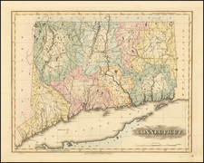
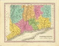
Full Original Publisher's Color Example
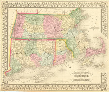
Rare full color example of the Mathew Carey's map of Connecticut, engraved by Amos Doolittle, which first appeared the 1795 edition of Carey's American Atlas.
Carey's American Atlas was the first atlas published in the United States, compiling a number of excellent maps from indigenous sources in the first compilation of American maps.
This map was engraved by Amos Doolittle in New Haven and bears his name, on a scale of 7.5 miles to one inch. The towns and township lines are based on William Blodget's seminal map of 1791, but the coastal and river information derives from other sources. This second edition of the map (offered here) can be distinguished from the exceptionally rare separately issued first state by the addition of 3 trees east of the Hudson River in Greenwich County, near the disputed oblong portion of the western border with New York. An essential map for Connecticut collectors.
Amos Doolittle was a famous and prolific Connecticut engraver whose work appeared for nearly 40 years and is highly collected.
This is the first full wash color example we have offered for sale (1992-2024). Carey was the first American mapmaker to offer an outline color atlas, but only a few known examples of the atlas survive in full wash coloring.