


|
||

|

|
|

|
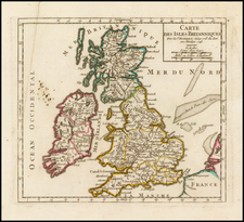
First edition of Sanson's map of the British Isles, engraved by Melchior Tavernier.
Nice example of Sanson's first map of the British Isles. The distortion of lreland and the condensed size of Scotland is ,in part, caused by the projection used by Sanson. This map was much copied by other French publishers around the 1645 and also by Richard Blome (in London) in 1669. Blome's map was engraved by Francis Lamb and - unusually for Blome - acknowledged its source as being Sanson.
Nicolas Sanson (1600-67) was an influential cartographer who is described by many authorities as the founder of the French School of Geography. In his early days he was tutor to Louis XIII and after his death in 1667 the business was continued by his three sons, Nicolas, Adrian and Guillaume. Later, his grandson, Pierre Moulard-Sanson and then his nephew, Gilles Robert de Vaugondy, continued the firm until the end of the eighteenth century.
The son of famous French cartographer Nicolas Sanson, Guillaume (1633-1703) carried on his father's work. Like his sire, he was a court geographer to Louis XIV. He often worked in partnership with another prominent cartographer of the time, Hubert Jaillot.
![[ Atlas ] Les Isles Britanniques, l'Espagne, la France, l'Italie, & l'Allemagne Descrites en plusieurs Cartes, & divers Traictés suivant les principales distinctions qui s'y pevuent remarquer chez les Anciens Autheurs, & chez les Modernes. [The British Isles, Spain, France, Italy, & Germany Described in Several Maps, and Various Treatises Following the Main Distinctions Noted by Ancient and Modern Authors.]](https://storage.googleapis.com/raremaps/img/small/105348.jpg)

![Ancient Britain (North Sheet) [and] Ancient Britain (South Sheet)](https://storage.googleapis.com/raremaps/img/small/92968.jpg)