


|
||

|

|
|

|
Stock# 104085
Description
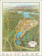
This is a colorful, pictorial map of Las Vegas from around the 1960s, highlighting tourist attractions and key landmarks.
The map features a playful design, with illustrations such as a smiling sun, indicative of the era's style. Key locations like the famous Las Vegas Strip, golf courses, and the Hoover Dam are marked, alongside roads, geographical features, and the boundaries of neighboring states. Text blocks provide information on points of interest, promoting the leisure and entertainment options available in the city.
The overall tone suggests a vibrant, bustling destination, encapsulating the spirit of Las Vegas during that time.
Condition Description
Minor tape stain

![(Cold War) State of Nevada Operational Survival Plan Project [with:] Alert Today Alive Tomorrow (budget plan for Nevada Civil Defense Act) [and with:] What You Should Know About the National Plan for Civil Defense and Defense Mobilization](https://storage.googleapis.com/raremaps/img/small/97464.jpg)