|
||

|

|
|

|
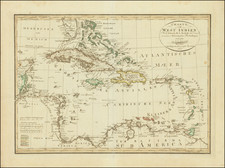
This late 20th-century pictorial map presents the Caribbean Sea with the surrounding landmasses and islands, rendered in a style reminiscent of historical maritime charts.
The map is ornate, featuring a decorative border and elaborate title cartouche that reads "The West Indies." The map illustrates various islands such as Cuba, the Bahamas, Puerto Rico, and the Lesser Antilles, with a noticeable focus on topographical features and place names.
Iconic imagery like a galleon, a mermaid with a swan, and sea creatures enhance the nautical theme. A compass rose sits prominently to the southeast, adding to the map's navigational feel.
The artistic details and the inclusion of historical references imbue the map with a sense of the region's rich maritime history and cultural heritage.
![Cuba Insula [with] Hispaniola Insula [with] Insula Jamaica [with] Ins. S. Ioannis [with] I.S. Margareta Cum Confiniis](https://storage.googleapis.com/raremaps/img/small/95802.jpg)