|
||

|

|
|

|
Not In Wheat
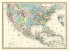
An early example of the United States mapped coast to coast.
The map is especially interesting west of the Mississippi, where it shows a double wide Arkansaw Territory, Oregon Territory extending from the Mississippi to the Pacific, early regional reference to Texas, two Salt Lakes with two rivers flowing to the Pacific, fabulous detail in the Pacific Northwest relying upon Lewis & Clark and the Hudson's Bay Co writings, etc.
The map is one of the most detailed renderings of the drainage systems of the Rockies and Upper Mississippi prior to Nicollet. Several early forts are shown in Texas.
The Missions and early mythical rivers shown in California.
Rarity
The 1825 edition of this map is very rare. This is the second example we have offered for sale (1992-2024).
Andre Hubert Brué was a French geographer and cartographer. Born in Paris, he served in the French Navy, joining the Baudin expedition to the Pacific (1800-1804). After his sea service, Brué applied his navigation and charting skills to creating finely-crafted maps, which were renowned for their crisp engraving and accuracy. He drew directly on the copper of the plate, creating what he called encyprotypes. He is best known for the Atlas universal de géographie physique, politique, ancienne et moderne.
![A Map of Lewis and Clark's Track Across the Western Portion of North America, from the Mississippi to the Pacific Ocean. By Order of the Executive of the United States in 1804, 5 & 6. . . . [Complete with 3 volumes of Text: Travels to the Source of the Missouri River and Across the American Continent to the Pacific Ocean. Performed by Order of the Government of the United States, in the Years 1804, 1805, and 1806].](https://storage.googleapis.com/raremaps/img/small/81775.jpg)

![A New and Exact Map of the Dominions of the King of Great Britain on ye Continent of North America . . . [Beaver map]](https://storage.googleapis.com/raremaps/img/small/101277.jpg)